Wapello elevation
Wapello (Iowa, Louisa County), United States elevation is 179 meters and Wapello elevation in feet is 587 ft above sea level [src 1]. Wapello is a seat of a second-order administrative division (feature code) with elevation that is 100 meters (328 ft) smaller than average city elevation in United States.
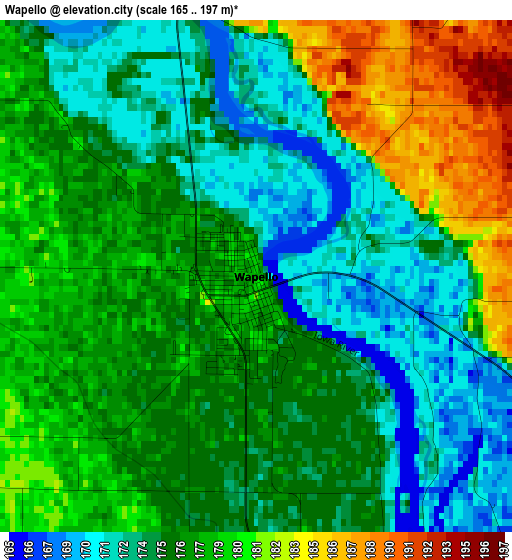
Below is the Elevation map of Wapello, which displays elevation range with different colors. Scale of the first map is from 165 to 197 m (541 to 646 ft) with average elevation of 176.3 meters (=578 ft) [note 1]
These maps also provides idea of topography and contour of this city, they are displayed at different zoom levels. More info about maps, scale and edge coordinates you can find below images.

| \ | Map #1 | Topo.Map |
| Scale [m] | 165..197 m | × |
| Scale [ft] | 541..646 ft | × |
| Average | 176.3 m = 578 ft | × |
| Width | 7.36 km = 4.6 mi | 235.4 km = 146.3 mi |
| Height | 7.36 km = 4.6 mi | 235.4 km = 146.3 mi |
| ↑Max Latitude | 41.214486° | 42.23124° |
| Latitude at center | 41.18142° | 41.18142° |
| ↓Min Latitude | 41.148337° | 40.1145° |
| ← Min Longitude | -91.229375° | -92.59168° |
| Longitude center | -91.18543° | -91.18543° |
| →Max Longitude | -91.141485° | -89.77918° |
Nearby cities:
Cities around Wapello sort by population:
• Burlington elevation 189 m
42 km,  171°
171°
• Muscatine 178 m
29.5 km,  23°
23°
• Mount Pleasant 221 m
39.5 km,  232°
232°
• West Liberty 207 m
43.7 km,  351°
351°
• Aledo 226 m
36.5 km,  86°
86°
• West Burlington 214 m
39.7 km,  176°
176°
• New London 237 m
33.5 km,  212°
212°
• Columbus Junction 186 m
18.3 km,  306°
306°
• Mediapolis 237 m
19.4 km, 174°
• Lone Tree 220 m
39.6 km,  329°
329°
• Oquawka 170 m
34.2 km,  144°
144°
• Winfield 209 m
22.4 km,  253°
253°
Multilingual:
 En español:
Wapello elevación 179 m.
 En France:
Wapello élévation 179 m.


Sources and notes:
- [note 1] Map square and city borders are not equal. Map elevation data is calculated only from area inside that square.
- [src 1] Elevation data from geonames database provided with same terms of usage.
- [src 2] The elevation map of Wapello is generated using elevation data from NASA's 3 arcsec (90m) resolution SRTM data.
- [src 3] Base (background) map © OpenStreetMap contributors tiles are generated by Geofabrik and OpenTopoMap.
Copyright & License:
This Wapello Elevation Map is licensed under CC BY-SA. You may reuse any part from this page, if you give a proper credit by linking to this URL:
 More info on terms of use page.