Manchester elevation
Manchester (Iowa, Delaware County), United States elevation is 289 meters and Manchester elevation in feet is 948 ft above sea level [src 1]. Manchester is a seat of a second-order administrative division (feature code) with elevation that is 10 meters (33 ft) bigger than average city elevation in United States.
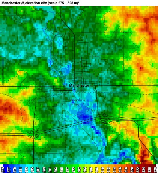
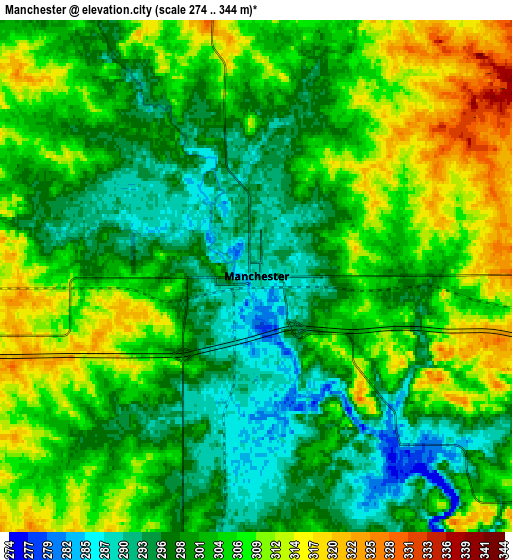
Below is the Elevation map of Manchester, which displays elevation range with different colors. Scale of the first map is from 275 to 328 m (902 to 1076 ft) with average elevation of 296.1 meters (=971 ft) [note 1]
These maps also provides idea of topography and contour of this city, they are displayed at different zoom levels. More info about maps, scale and edge coordinates you can find below images.
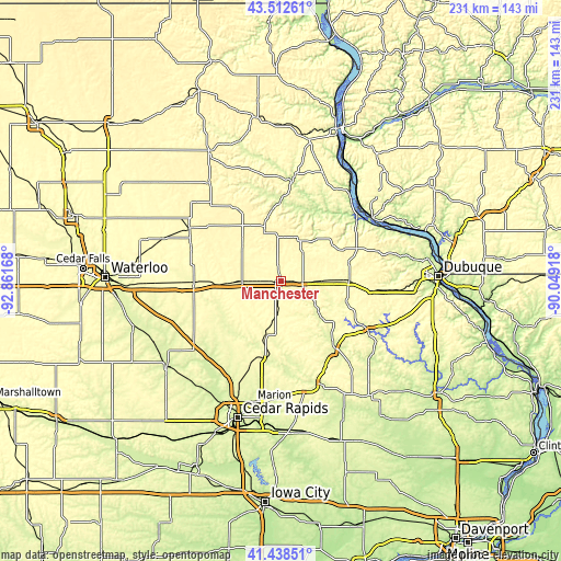
| \ | Map #1 | Map #2 | Topo.Map |
| Scale [m] | 275..328 m | 274..344 m | × |
| Scale [ft] | 902..1076 ft | 899..1129 ft | × |
| Average | 296.1 m = 971 ft | 302.9 m = 994 ft | × |
| Width | 7.21 km = 4.5 mi | 14.41 km = 9 mi | 230.6 km = 143.3 mi |
| Height | 7.21 km = 4.5 mi | 14.41 km = 9 mi | 230.6 km = 143.3 mi |
| ↑Max Latitude | 42.51655° | 42.548933° | 43.51261° |
| Latitude at center | 42.48415° | 42.48415° | 42.48415° |
| ↓Min Latitude | 42.451734° | 42.4193° | 41.43851° |
| ← Min Longitude | -91.499375° | -91.543321° | -92.86168° |
| Longitude center | -91.45543° | -91.45543° | -91.45543° |
| →Max Longitude | -91.411485° | -91.367539° | -90.04918° |
Nearby cities:
Cities around Manchester sort by population:
• Oelwein elevation 317 m
43 km,  299°
299°
• Independence 285 m
35.6 km,  267°
267°
• Anamosa 257 m
44.1 km,  161°
161°
• Dyersville 294 m
27.3 km,  89°
89°
• Monticello 256 m
35.1 km,  141°
141°
• Center Point 254 m
42.4 km,  219°
219°
• Cascade 253 m
41.6 km,  119°
119°
• Epworth 320 m
43.1 km,  95°
95°
• Farley 344 m
37.1 km, 97°
• Central City 256 m
31.7 km,  190°
190°
• Strawberry Point 372 m
23.1 km,  343°
343°
• Elkader 226 m
41.3 km,  5°
5°
Multilingual:
 En español:
Manchester elevación 289 m.
 En France:
Manchester élévation 289 m.
 Auf Deutsch:
Manchester höhe über dem Meeresspiegel ist 289 m.

Sources and notes:
- [note 1] Map square and city borders are not equal. Map elevation data is calculated only from area inside that square.
- [src 1] Elevation data from geonames database provided with same terms of usage.
- [src 2] The elevation map of Manchester is generated using elevation data from NASA's 3 arcsec (90m) resolution SRTM data.
- [src 3] Base (background) map © OpenStreetMap contributors tiles are generated by Geofabrik and OpenTopoMap.
Copyright & License:
This Manchester Elevation Map is licensed under CC BY-SA. You may reuse any part from this page, if you give a proper credit by linking to this URL:
 More info on terms of use page.