Anamosa elevation
Anamosa (Iowa, Jones County), United States elevation is 257 meters and Anamosa elevation in feet is 843 ft above sea level [src 1]. Anamosa is a seat of a second-order administrative division (feature code) with elevation that is 22 meters (72 ft) smaller than average city elevation in United States.
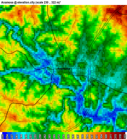
Below is the Elevation map of Anamosa, which displays elevation range with different colors. Scale of the first map is from 230 to 322 m (755 to 1056 ft) with average elevation of 268.6 meters (=881 ft) [note 1]
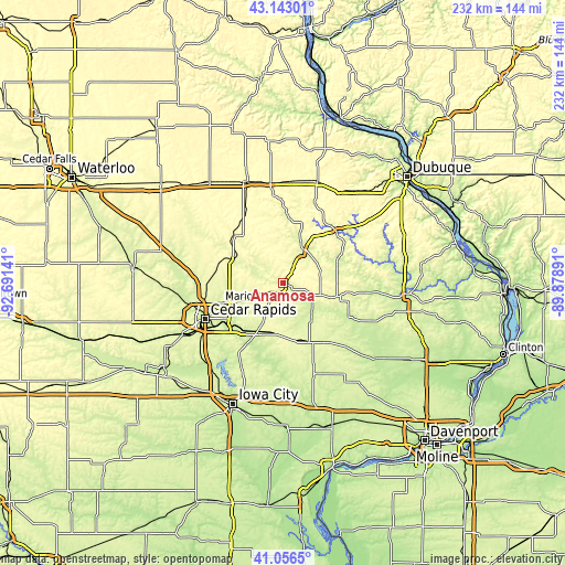
These maps also provides idea of topography and contour of this city, they are displayed at different zoom levels. More info about maps, scale and edge coordinates you can find below images.
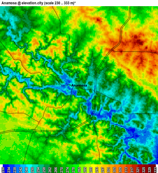
| \ | Map #1 | Map #2 | Topo.Map |
| Scale [m] | 230..322 m | 230..333 m | × |
| Scale [ft] | 755..1056 ft | 755..1093 ft | × |
| Average | 268.6 m = 881 ft | 275.5 m = 904 ft | × |
| Width | 7.25 km = 4.5 mi | 14.5 km = 9 mi | 232 km = 144.2 mi |
| Height | 7.25 km = 4.5 mi | 14.5 km = 9 mi | 232 km = 144.2 mi |
| ↑Max Latitude | 42.140934° | 42.173511° | 43.14301° |
| Latitude at center | 42.10834° | 42.10834° | 42.10834° |
| ↓Min Latitude | 42.07573° | 42.043102° | 41.0565° |
| ← Min Longitude | -91.329105° | -91.373051° | -92.69141° |
| Longitude center | -91.28516° | -91.28516° | -91.28516° |
| →Max Longitude | -91.241215° | -91.197269° | -89.87891° |
Nearby cities:
Cities around Anamosa sort by population:
• Cedar Rapids elevation 251 m
31.6 km,  249°
249°
• Marion 262 m
27.1 km, 252°
• Hiawatha 261 m
33.7 km,  256°
256°
• Mount Vernon 268 m
23.4 km,  207°
207°
• Monticello 256 m
16.6 km,  29°
29°
• Robins 261 m
31.8 km, 262°
• Cascade 253 m
30.7 km,  46°
46°
• Lisbon 265 m
22.4 km,  201°
201°
• Ely 225 m
36 km,  223°
223°
• Central City 256 m
22.4 km,  298°
298°
• Springville 256 m
14.1 km, 247°
• Mechanicsville 279 m
22.8 km,  173°
173°
Multilingual:
 En español:
Anamosa elevación 257 m.
 En France:
Anamosa élévation 257 m.


Sources and notes:
- [note 1] Map square and city borders are not equal. Map elevation data is calculated only from area inside that square.
- [src 1] Elevation data from geonames database provided with same terms of usage.
- [src 2] The elevation map of Anamosa is generated using elevation data from NASA's 3 arcsec (90m) resolution SRTM data.
- [src 3] Base (background) map © OpenStreetMap contributors tiles are generated by Geofabrik and OpenTopoMap.
Copyright & License:
This Anamosa Elevation Map is licensed under CC BY-SA. You may reuse any part from this page, if you give a proper credit by linking to this URL:
 More info on terms of use page.