Cedar Rapids elevation
Cedar Rapids (Iowa, Linn County), United States elevation is 251 meters and Cedar Rapids elevation in feet is 823 ft above sea level [src 1]. Cedar Rapids is a seat of a second-order administrative division (feature code) with elevation that is 28 meters (92 ft) smaller than average city elevation in United States.
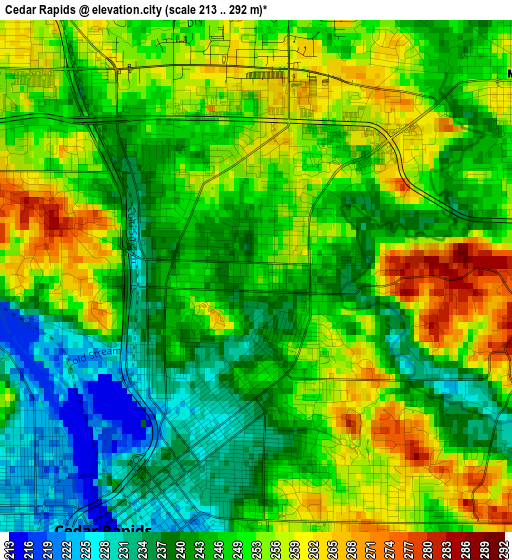
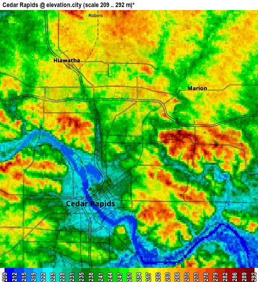
Below is the Elevation map of Cedar Rapids, which displays elevation range with different colors. Scale of the first map is from 213 to 292 m (699 to 958 ft) with average elevation of 248.3 meters (=815 ft) [note 1]
These maps also provides idea of topography and contour of this city, they are displayed at different zoom levels. More info about maps, scale and edge coordinates you can find below images.
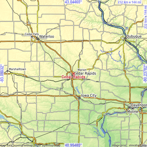
| \ | Map #1 | Map #2 | Topo.Map |
| Scale [m] | 213..292 m | 209..292 m | × |
| Scale [ft] | 699..958 ft | 686..958 ft | × |
| Average | 248.3 m = 815 ft | 248.1 m = 814 ft | × |
| Width | 7.26 km = 4.5 mi | 14.52 km = 9 mi | 232.4 km = 144.4 mi |
| Height | 7.26 km = 4.5 mi | 14.52 km = 9 mi | 232.4 km = 144.4 mi |
| ↑Max Latitude | 42.040975° | 42.073603° | 43.04465° |
| Latitude at center | 42.00833° | 42.00833° | 42.00833° |
| ↓Min Latitude | 41.975668° | 41.94299° | 40.95485° |
| ← Min Longitude | -91.688015° | -91.731961° | -93.05032° |
| Longitude center | -91.64407° | -91.64407° | -91.64407° |
| →Max Longitude | -91.600125° | -91.556179° | -90.23782° |
Nearby cities:
Cities around Cedar Rapids sort by population:
• Marion elevation 262 m
4.8 km,  53°
53°
• Hiawatha 261 m
4.4 km,  314°
314°
• Mount Vernon 268 m
21.1 km,  117°
117°
• Robins 261 m
7.2 km,  344°
344°
• Center Point 254 m
23.4 km,  330°
330°
• Fairfax 235 m
15 km,  228°
228°
• Lisbon 265 m
23.5 km,  114°
114°
• Ely 225 m
15.8 km,  161°
161°
• Atkins 262 m
18.1 km,  265°
265°
• Walford 245 m
21.4 km, 227°
• Springville 256 m
17.6 km,  71°
71°
• Palo 229 m
14.1 km,  297°
297°
Multilingual:
 En español:
Cedar Rapids elevación 251 m.
 En France:
Cedar Rapids élévation 251 m.
 Auf Deutsch:
Cedar Rapids höhe über dem Meeresspiegel ist 251 m.

Sources and notes:
- [note 1] Map square and city borders are not equal. Map elevation data is calculated only from area inside that square.
- [src 1] Elevation data from geonames database provided with same terms of usage.
- [src 2] The elevation map of Cedar Rapids is generated using elevation data from NASA's 3 arcsec (90m) resolution SRTM data.
- [src 3] Base (background) map © OpenStreetMap contributors tiles are generated by Geofabrik and OpenTopoMap.
Copyright & License:
This Cedar Rapids Elevation Map is licensed under CC BY-SA. You may reuse any part from this page, if you give a proper credit by linking to this URL:
 More info on terms of use page.