Keokuk elevation
Keokuk (Iowa, Lee County), United States elevation is 174 meters and Keokuk elevation in feet is 571 ft above sea level [src 1]. Keokuk is a populated place (feature code) with elevation that is 105 meters (344 ft) smaller than average city elevation in United States.
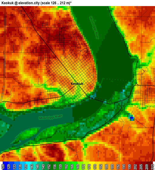
Below is the Elevation map of Keokuk, which displays elevation range with different colors. Scale of the first map is from 126 to 212 m (413 to 696 ft) with average elevation of 178.7 meters (=586 ft) [note 1]
These maps also provides idea of topography and contour of this city, they are displayed at different zoom levels. More info about maps, scale and edge coordinates you can find below images.
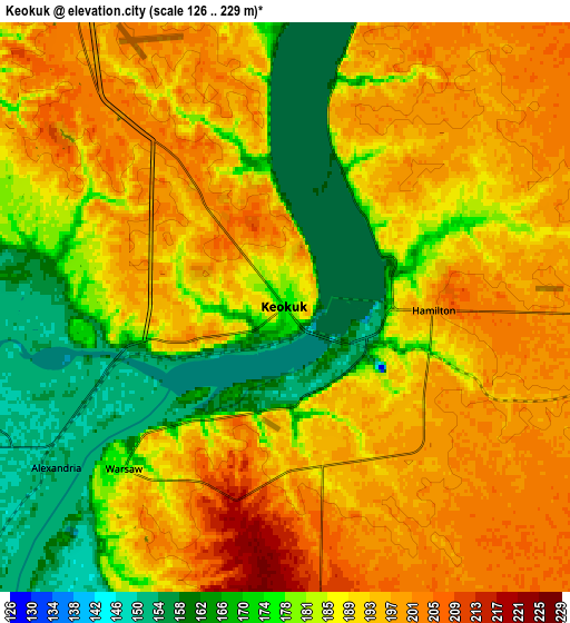
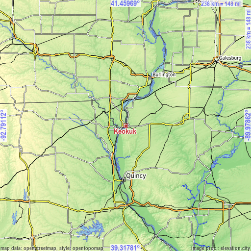
| \ | Map #1 | Map #2 | Topo.Map |
| Scale [m] | 126..212 m | 126..229 m | × |
| Scale [ft] | 413..696 ft | 413..751 ft | × |
| Average | 178.7 m = 586 ft | 187 m = 614 ft | × |
| Width | 7.44 km = 4.6 mi | 14.88 km = 9.2 mi | 238.2 km = 148 mi |
| Height | 7.44 km = 4.6 mi | 14.88 km = 9.2 mi | 238.1 km = 147.9 mi |
| ↑Max Latitude | 40.430729° | 40.464172° | 41.45969° |
| Latitude at center | 40.39727° | 40.39727° | 40.39727° |
| ↓Min Latitude | 40.363794° | 40.330302° | 39.31781° |
| ← Min Longitude | -91.428815° | -91.472761° | -92.79112° |
| Longitude center | -91.38487° | -91.38487° | -91.38487° |
| →Max Longitude | -91.340925° | -91.296979° | -89.97862° |
Nearby cities:
Cities around Keokuk sort by population:
• Burlington elevation 189 m
51.1 km,  26°
26°
• Fort Madison 161 m
26.5 km,  12°
12°
• Hamilton 199 m
3.9 km,  91°
91°
• Carthage 206 m
21.2 km,  84°
84°
• Canton 183 m
36.5 km,  213°
213°
• Kahoka 216 m
28.5 km,  275°
275°
• Warsaw 177 m
6 km,  224°
224°
• Colchester 214 m
50.2 km, 86°
• La Harpe 214 m
40.8 km,  59°
59°
• Camp Point 222 m
48 km,  146°
146°
• Nauvoo 199 m
17 km,  0°
0°
• Monticello 195 m
41.6 km, 221°
Multilingual:
 En español:
Keokuk elevación 174 m.
 En France:
Keokuk élévation 174 m.


Sources and notes:
- [note 1] Map square and city borders are not equal. Map elevation data is calculated only from area inside that square.
- [src 1] Elevation data from geonames database provided with same terms of usage.
- [src 2] The elevation map of Keokuk is generated using elevation data from NASA's 3 arcsec (90m) resolution SRTM data.
- [src 3] Base (background) map © OpenStreetMap contributors tiles are generated by Geofabrik and OpenTopoMap.
Copyright & License:
This Keokuk Elevation Map is licensed under CC BY-SA. You may reuse any part from this page, if you give a proper credit by linking to this URL:
 More info on terms of use page.