Carthage elevation
Carthage (Illinois, Hancock County), United States elevation is 206 meters and Carthage elevation in feet is 676 ft above sea level [src 1]. Carthage is a seat of a second-order administrative division (feature code) with elevation that is 73 meters (240 ft) smaller than average city elevation in United States.
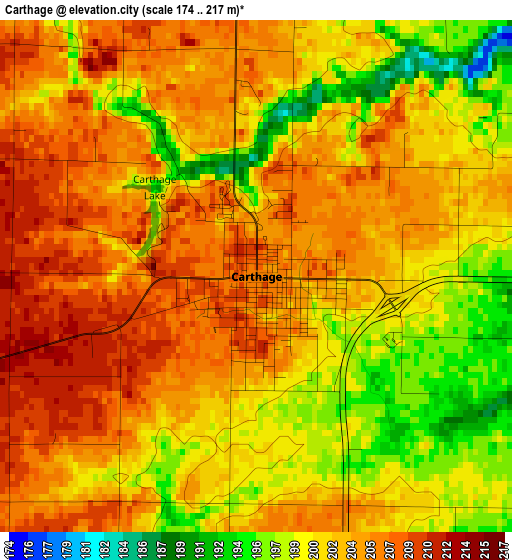
Below is the Elevation map of Carthage, which displays elevation range with different colors. Scale of the first map is from 174 to 217 m (571 to 712 ft) with average elevation of 202.8 meters (=665 ft) [note 1]
These maps also provides idea of topography and contour of this city, they are displayed at different zoom levels. More info about maps, scale and edge coordinates you can find below images.
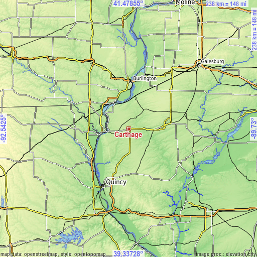
| \ | Map #1 | Topo.Map |
| Scale [m] | 174..217 m | × |
| Scale [ft] | 571..712 ft | × |
| Average | 202.8 m = 665 ft | × |
| Width | 7.44 km = 4.6 mi | 238.1 km = 147.9 mi |
| Height | 7.44 km = 4.6 mi | 238.1 km = 147.9 mi |
| ↑Max Latitude | 40.44988° | 41.47855° |
| Latitude at center | 40.41643° | 40.41643° |
| ↓Min Latitude | 40.382964° | 39.33728° |
| ← Min Longitude | -91.180195° | -92.5425° |
| Longitude center | -91.13625° | -91.13625° |
| →Max Longitude | -91.092305° | -89.73° |
Nearby cities:
Cities around Carthage sort by population:
• Burlington elevation 189 m
43.5 km,  2°
2°
• Macomb 216 m
39.6 km,  83°
83°
• Fort Madison 161 m
28.1 km,  327°
327°
• Keokuk 174 m
21.2 km,  264°
264°
• West Burlington 214 m
45.5 km,  357°
357°
• Hamilton 199 m
17.3 km, 262°
• Kahoka 216 m
49.4 km,  270°
270°
• Warsaw 177 m
26.1 km, 255°
• Colchester 214 m
29.1 km,  87°
87°
• La Harpe 214 m
23.3 km,  37°
37°
• Camp Point 222 m
42.3 km,  172°
172°
• Nauvoo 199 m
25.7 km,  305°
305°
Multilingual:
 En español:
Carthage elevación 206 m.
 En France:
Carthage élévation 206 m.
 Auf Deutsch:
Carthage höhe über dem Meeresspiegel ist 206 m.

Sources and notes:
- [note 1] Map square and city borders are not equal. Map elevation data is calculated only from area inside that square.
- [src 1] Elevation data from geonames database provided with same terms of usage.
- [src 2] The elevation map of Carthage is generated using elevation data from NASA's 3 arcsec (90m) resolution SRTM data.
- [src 3] Base (background) map © OpenStreetMap contributors tiles are generated by Geofabrik and OpenTopoMap.
Copyright & License:
This Carthage Elevation Map is licensed under CC BY-SA. You may reuse any part from this page, if you give a proper credit by linking to this URL:
 More info on terms of use page.