Canton elevation
Canton (Missouri, Lewis County), United States elevation is 183 meters and Canton elevation in feet is 600 ft above sea level [src 1]. Canton is a populated place (feature code) with elevation that is 96 meters (315 ft) smaller than average city elevation in United States.
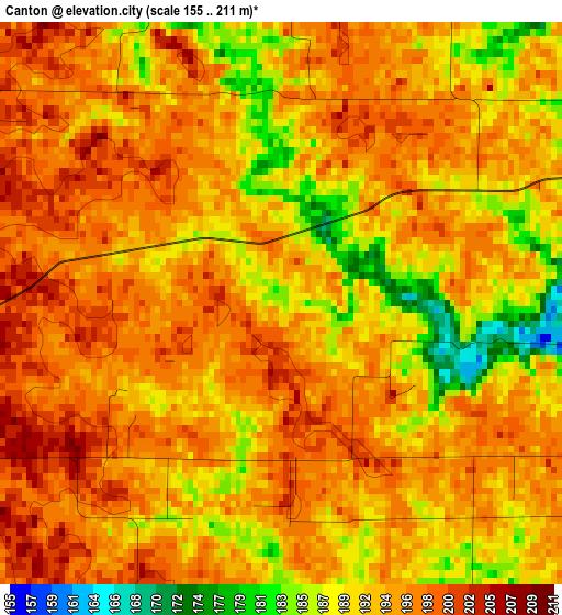
Below is the Elevation map of Canton, which displays elevation range with different colors. Scale of the first map is from 155 to 211 m (509 to 692 ft) with average elevation of 193.6 meters (=635 ft) [note 1]
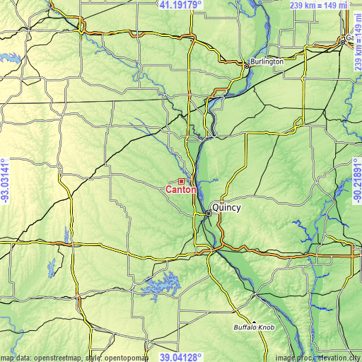
These maps also provides idea of topography and contour of this city, they are displayed at different zoom levels. More info about maps, scale and edge coordinates you can find below images.
| \ | Map #1 | Topo.Map |
| Scale [m] | 155..211 m | × |
| Scale [ft] | 509..692 ft | × |
| Average | 193.6 m = 635 ft | × |
| Width | 7.47 km = 4.6 mi | 239.1 km = 148.6 mi |
| Height | 7.47 km = 4.6 mi | 239.1 km = 148.6 mi |
| ↑Max Latitude | 40.158634° | 41.19179° |
| Latitude at center | 40.12504° | 40.12504° |
| ↓Min Latitude | 40.091429° | 39.04128° |
| ← Min Longitude | -91.669105° | -93.03141° |
| Longitude center | -91.62516° | -91.62516° |
| →Max Longitude | -91.581215° | -90.21891° |
Nearby cities:
Cities around Canton sort by population:
• Quincy elevation 167 m
27.9 km,  138°
138°
• Keokuk 174 m
36.5 km,  33°
33°
• Palmyra 201 m
37.8 km,  166°
166°
• Hamilton 199 m
38.7 km,  38°
38°
• Kahoka 216 m
33.8 km,  346°
346°
• Warsaw 177 m
30.7 km, 31°
• Camp Point 222 m
48.2 km,  101°
101°
• Nauvoo 199 m
51.5 km,  23°
23°
• Edina 249 m
46.8 km,  275°
275°
• Payson 230 m
47.3 km, 136°
• Shelbyville 234 m
50.2 km,  224°
224°
• Monticello 195 m
7.4 km,  264°
264°
Multilingual:
 En español:
Canton elevación 183 m.
 En France:
Canton élévation 183 m.


Sources and notes:
- [note 1] Map square and city borders are not equal. Map elevation data is calculated only from area inside that square.
- [src 1] Elevation data from geonames database provided with same terms of usage.
- [src 2] The elevation map of Canton is generated using elevation data from NASA's 3 arcsec (90m) resolution SRTM data.
- [src 3] Base (background) map © OpenStreetMap contributors tiles are generated by Geofabrik and OpenTopoMap.
Copyright & License:
This Canton Elevation Map is licensed under CC BY-SA. You may reuse any part from this page, if you give a proper credit by linking to this URL:
 More info on terms of use page.