Fayette elevation
Fayette (Iowa, Fayette County), United States elevation is 306 meters and Fayette elevation in feet is 1004 ft above sea level [src 1]. Fayette is a populated place (feature code) with elevation that is 27 meters (89 ft) bigger than average city elevation in United States.
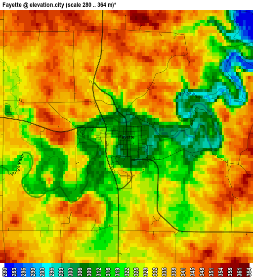
Below is the Elevation map of Fayette, which displays elevation range with different colors. Scale of the first map is from 280 to 364 m (919 to 1194 ft) with average elevation of 330.3 meters (=1084 ft) [note 1]
These maps also provides idea of topography and contour of this city, they are displayed at different zoom levels. More info about maps, scale and edge coordinates you can find below images.
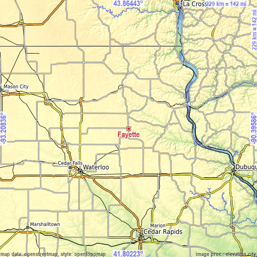
| \ | Map #1 | Topo.Map |
| Scale [m] | 280..364 m | × |
| Scale [ft] | 919..1194 ft | × |
| Average | 330.3 m = 1084 ft | × |
| Width | 7.17 km = 4.5 mi | 229.3 km = 142.5 mi |
| Height | 7.17 km = 4.5 mi | 229.3 km = 142.5 mi |
| ↑Max Latitude | 42.874144° | 43.86443° |
| Latitude at center | 42.84193° | 42.84193° |
| ↓Min Latitude | 42.809699° | 41.80223° |
| ← Min Longitude | -91.846055° | -93.20836° |
| Longitude center | -91.80211° | -91.80211° |
| →Max Longitude | -91.758165° | -90.39586° |
Nearby cities:
Cities around Fayette sort by population:
• Oelwein elevation 317 m
20.8 km,  205°
205°
• Independence 285 m
42.1 km,  189°
189°
• Jesup 299 m
46 km, 207°
• West Union 360 m
13.4 km,  357°
357°
• Postville 361 m
33 km,  35°
35°
• Sumner 324 m
23.6 km,  271°
271°
• Denver 286 m
47.6 km,  246°
246°
• Monona 372 m
40.9 km,  55°
55°
• Tripoli 316 m
37.4 km,  264°
264°
• Strawberry Point 372 m
28.1 km,  128°
128°
• Elkader 226 m
32.4 km,  87°
87°
• Fairbank 299 m
30.1 km,  221°
221°
Multilingual:
 En español:
Fayette elevación 306 m.
 En France:
Fayette élévation 306 m.


Sources and notes:
- [note 1] Map square and city borders are not equal. Map elevation data is calculated only from area inside that square.
- [src 1] Elevation data from geonames database provided with same terms of usage.
- [src 2] The elevation map of Fayette is generated using elevation data from NASA's 3 arcsec (90m) resolution SRTM data.
- [src 3] Base (background) map © OpenStreetMap contributors tiles are generated by Geofabrik and OpenTopoMap.
Copyright & License:
This Fayette Elevation Map is licensed under CC BY-SA. You may reuse any part from this page, if you give a proper credit by linking to this URL:
 More info on terms of use page.