Winsted elevation
Winsted (Connecticut, Litchfield County), United States elevation is 218 meters and Winsted elevation in feet is 715 ft above sea level [src 1]. Winsted is a populated place (feature code) with elevation that is 61 meters (200 ft) smaller than average city elevation in United States.
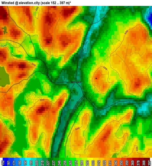
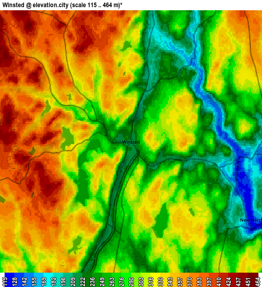
Below is the Elevation map of Winsted, which displays elevation range with different colors. Scale of the first map is from 152 to 397 m (499 to 1302 ft) with average elevation of 289.2 meters (=949 ft) [note 1]
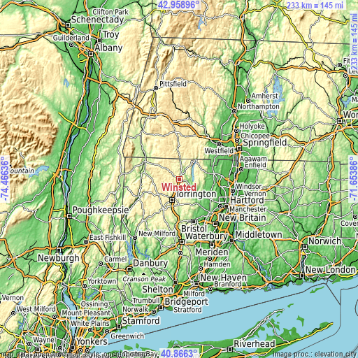
These maps also provides idea of topography and contour of this city, they are displayed at different zoom levels. More info about maps, scale and edge coordinates you can find below images.
| \ | Map #1 | Map #2 | Topo.Map |
| Scale [m] | 152..397 m | 115..464 m | × |
| Scale [ft] | 499..1302 ft | 377..1522 ft | × |
| Average | 289.2 m = 949 ft | 305 m = 1001 ft | × |
| Width | 7.27 km = 4.5 mi | 14.54 km = 9 mi | 232.7 km = 144.6 mi |
| Height | 7.27 km = 4.5 mi | 14.54 km = 9 mi | 232.7 km = 144.6 mi |
| ↑Max Latitude | 41.9539° | 41.986573° | 42.95896° |
| Latitude at center | 41.92121° | 41.92121° | 41.92121° |
| ↓Min Latitude | 41.888503° | 41.85578° | 40.8663° |
| ← Min Longitude | -73.104055° | -73.148001° | -74.46636° |
| Longitude center | -73.06011° | -73.06011° | -73.06011° |
| →Max Longitude | -73.016165° | -72.972219° | -71.65386° |
Nearby cities:
Cities around Winsted sort by population:
• West Torrington elevation 201 m
13.4 km,  211°
211°
• Torrington 169 m
14.3 km,  200°
200°
• Winchester Center 406 m
6.6 km,  249°
249°
• Simsbury Center 87 m
21.1 km,  102°
102°
• Collinsville 103 m
16.7 km,  136°
136°
• Northwest Harwinton 295 m
16.1 km,  185°
185°
• Weatogue 93 m
21 km,  114°
114°
• West Simsbury 99 m
17.5 km, 107°
• North Granby 86 m
20.8 km,  66°
66°
• Canton Valley 209 m
17 km,  124°
124°
• New Hartford Center 130 m
8.4 km, 123°
• Litchfield 335 m
22.1 km, 208°
Multilingual:
 En español:
Winsted elevación 218 m.
 En France:
Winsted élévation 218 m.


Sources and notes:
- [note 1] Map square and city borders are not equal. Map elevation data is calculated only from area inside that square.
- [src 1] Elevation data from geonames database provided with same terms of usage.
- [src 2] The elevation map of Winsted is generated using elevation data from NASA's 3 arcsec (90m) resolution SRTM data.
- [src 3] Base (background) map © OpenStreetMap contributors tiles are generated by Geofabrik and OpenTopoMap.
Copyright & License:
This Winsted Elevation Map is licensed under CC BY-SA. You may reuse any part from this page, if you give a proper credit by linking to this URL:
 More info on terms of use page.