Weatogue elevation
Weatogue (Connecticut, Hartford County), United States elevation is 93 meters and Weatogue elevation in feet is 305 ft above sea level [src 1]. Weatogue is a populated place (feature code) with elevation that is 186 meters (610 ft) smaller than average city elevation in United States.
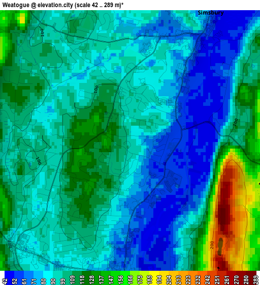
Below is the Elevation map of Weatogue, which displays elevation range with different colors. Scale of the first map is from 42 to 289 m (138 to 948 ft) with average elevation of 98.8 meters (=324 ft) [note 1]
These maps also provides idea of topography and contour of this city, they are displayed at different zoom levels. More info about maps, scale and edge coordinates you can find below images.
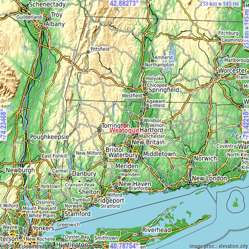
| \ | Map #1 | Topo.Map |
| Scale [m] | 42..289 m | × |
| Scale [ft] | 138..948 ft | × |
| Average | 98.8 m = 324 ft | × |
| Width | 7.28 km = 4.5 mi | 233 km = 144.8 mi |
| Height | 7.28 km = 4.5 mi | 233 km = 144.8 mi |
| ↑Max Latitude | 41.876439° | 42.88273° |
| Latitude at center | 41.84371° | 41.84371° |
| ↓Min Latitude | 41.810964° | 40.78754° |
| ← Min Longitude | -72.872375° | -74.23468° |
| Longitude center | -72.82843° | -72.82843° |
| →Max Longitude | -72.784485° | -71.42218° |
Nearby cities:
Cities around Weatogue sort by population:
• Hartford elevation 27 m
14.8 km,  126°
126°
• West Hartford 41 m
11.6 km,  141°
141°
• Windsor 18 m
15.3 km,  86°
86°
• Farmington 80 m
13.8 km,  181°
181°
• Simsbury Center 87 m
4.4 km,  19°
19°
• Collinsville 103 m
8.3 km,  245°
245°
• Blue Hills 45 m
11.4 km,  107°
107°
• West Simsbury 99 m
4.1 km,  323°
323°
• Salmon Brook 71 m
12.8 km,  12°
12°
• Canton Valley 209 m
5.4 km,  258°
258°
• New Hartford Center 130 m
12.8 km,  288°
288°
• Tariffville 55 m
9.2 km,  38°
38°
Multilingual:
 En español:
Weatogue elevación 93 m.
 En France:
Weatogue élévation 93 m.


Sources and notes:
- [note 1] Map square and city borders are not equal. Map elevation data is calculated only from area inside that square.
- [src 1] Elevation data from geonames database provided with same terms of usage.
- [src 2] The elevation map of Weatogue is generated using elevation data from NASA's 3 arcsec (90m) resolution SRTM data.
- [src 3] Base (background) map © OpenStreetMap contributors tiles are generated by Geofabrik and OpenTopoMap.
Copyright & License:
This Weatogue Elevation Map is licensed under CC BY-SA. You may reuse any part from this page, if you give a proper credit by linking to this URL:
 More info on terms of use page.