Tolland elevation
Tolland (Connecticut, Tolland County), United States elevation is 207 meters and Tolland elevation in feet is 679 ft above sea level [src 1]. Tolland is a populated place (feature code) with elevation that is 72 meters (236 ft) smaller than average city elevation in United States.
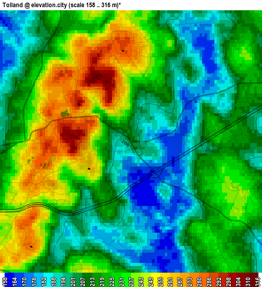
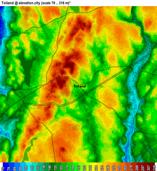
Below is the Elevation map of Tolland, which displays elevation range with different colors. Scale of the first map is from 158 to 316 m (518 to 1037 ft) with average elevation of 218.7 meters (=718 ft) [note 1]
These maps also provides idea of topography and contour of this city, they are displayed at different zoom levels. More info about maps, scale and edge coordinates you can find below images.
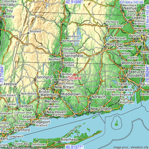
| \ | Map #1 | Map #2 | Topo.Map |
| Scale [m] | 158..316 m | 70..316 m | × |
| Scale [ft] | 518..1037 ft | 230..1037 ft | × |
| Average | 218.7 m = 718 ft | 198.5 m = 651 ft | × |
| Width | 7.28 km = 4.5 mi | 14.55 km = 9 mi | 232.9 km = 144.7 mi |
| Height | 7.28 km = 4.5 mi | 14.55 km = 9 mi | 232.9 km = 144.7 mi |
| ↑Max Latitude | 41.904205° | 41.936904° | 42.91006° |
| Latitude at center | 41.87149° | 41.87149° | 41.87149° |
| ↓Min Latitude | 41.838758° | 41.806009° | 40.81577° |
| ← Min Longitude | -72.412635° | -72.456581° | -73.77494° |
| Longitude center | -72.36869° | -72.36869° | -72.36869° |
| →Max Longitude | -72.324745° | -72.280799° | -70.96244° |
Nearby cities:
Cities around Tolland sort by population:
• Manchester elevation 87 m
16.5 km,  229°
229°
• Mansfield City 154 m
16.2 km,  136°
136°
• Storrs 192 m
12.1 km,  125°
125°
• Ellington 80 m
9.1 km,  293°
293°
• Stafford 181 m
14.2 km,  27°
27°
• Rockville 120 m
6.7 km,  265°
265°
• Stafford Springs 153 m
10.7 km, 30°
• East Windsor 42 m
15.3 km, 287°
• Coventry Lake 159 m
11.4 km,  164°
164°
• Crystal Lake 213 m
6.7 km,  353°
353°
• Somers 79 m
14.2 km,  333°
333°
• South Coventry 160 m
12.4 km,  154°
154°
Multilingual:
 En español:
Tolland elevación 207 m.
 En France:
Tolland élévation 207 m.


Sources and notes:
- [note 1] Map square and city borders are not equal. Map elevation data is calculated only from area inside that square.
- [src 1] Elevation data from geonames database provided with same terms of usage.
- [src 2] The elevation map of Tolland is generated using elevation data from NASA's 3 arcsec (90m) resolution SRTM data.
- [src 3] Base (background) map © OpenStreetMap contributors tiles are generated by Geofabrik and OpenTopoMap.
Copyright & License:
This Tolland Elevation Map is licensed under CC BY-SA. You may reuse any part from this page, if you give a proper credit by linking to this URL:
 More info on terms of use page.