East Brooklyn elevation
East Brooklyn (Connecticut, Windham County), United States elevation is 86 meters and East Brooklyn elevation in feet is 282 ft above sea level [src 1]. East Brooklyn is a populated place (feature code) with elevation that is 193 meters (633 ft) smaller than average city elevation in United States.
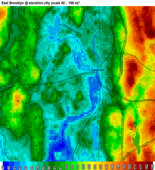
Below is the Elevation map of East Brooklyn, which displays elevation range with different colors. Scale of the first map is from 40 to 188 m (131 to 617 ft) with average elevation of 96.1 meters (=315 ft) [note 1]
These maps also provides idea of topography and contour of this city, they are displayed at different zoom levels. More info about maps, scale and edge coordinates you can find below images.
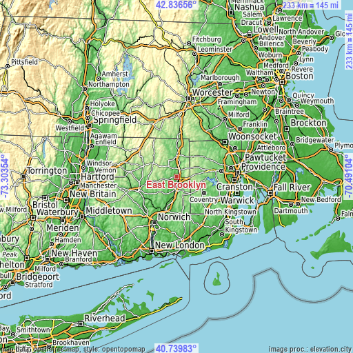
| \ | Map #1 | Topo.Map |
| Scale [m] | 40..188 m | × |
| Scale [ft] | 131..617 ft | × |
| Average | 96.1 m = 315 ft | × |
| Width | 7.29 km = 4.5 mi | 233.1 km = 144.8 mi |
| Height | 7.29 km = 4.5 mi | 233.1 km = 144.8 mi |
| ↑Max Latitude | 41.829523° | 42.83656° |
| Latitude at center | 41.79677° | 41.79677° |
| ↓Min Latitude | 41.764° | 40.73983° |
| ← Min Longitude | -71.941235° | -73.30354° |
| Longitude center | -71.89729° | -71.89729° |
| →Max Longitude | -71.853345° | -70.49104° |
Nearby cities:
Cities around East Brooklyn sort by population:
• Coventry elevation 112 m
20.8 km,  121°
121°
• Killingly Center 104 m
5.2 km,  26°
26°
• Plainfield 63 m
13.5 km,  186°
186°
• Thompson 180 m
18.2 km,  9°
9°
• Putnam 89 m
13.2 km,  355°
355°
• Foster 223 m
13.2 km,  61°
61°
• Danielson 66 m
1.1 km, 55°
• Moosup 76 m
9.4 km,  171°
171°
• Plainfield Village 60 m
13.5 km, 189°
• North Grosvenor Dale 110 m
21 km, 359°
• South Woodstock 123 m
16.6 km,  341°
341°
• Wauregan 66 m
5.9 km, 189°
Multilingual:
 En español:
East Brooklyn elevación 86 m.
 En France:
East Brooklyn élévation 86 m.
 Auf Deutsch:
East Brooklyn höhe über dem Meeresspiegel ist 86 m.

Sources and notes:
- [note 1] Map square and city borders are not equal. Map elevation data is calculated only from area inside that square.
- [src 1] Elevation data from geonames database provided with same terms of usage.
- [src 2] The elevation map of East Brooklyn is generated using elevation data from NASA's 3 arcsec (90m) resolution SRTM data.
- [src 3] Base (background) map © OpenStreetMap contributors tiles are generated by Geofabrik and OpenTopoMap.
Copyright & License:
This East Brooklyn Elevation Map is licensed under CC BY-SA. You may reuse any part from this page, if you give a proper credit by linking to this URL:
 More info on terms of use page.