Radford elevation
Radford (Virginia, City of Radford), United States elevation is 570 meters and Radford elevation in feet is 1870 ft above sea level [src 1]. Radford is a seat of a second-order administrative division (feature code) with elevation that is 291 meters (955 ft) bigger than average city elevation in United States.
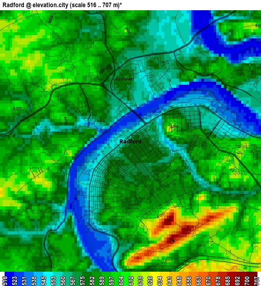
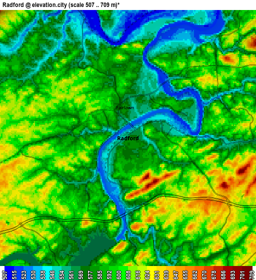
Below is the Elevation map of Radford, which displays elevation range with different colors. Scale of the first map is from 516 to 707 m (1693 to 2320 ft) with average elevation of 581.1 meters (=1906 ft) [note 1]
These maps also provides idea of topography and contour of this city, they are displayed at different zoom levels. More info about maps, scale and edge coordinates you can find below images.
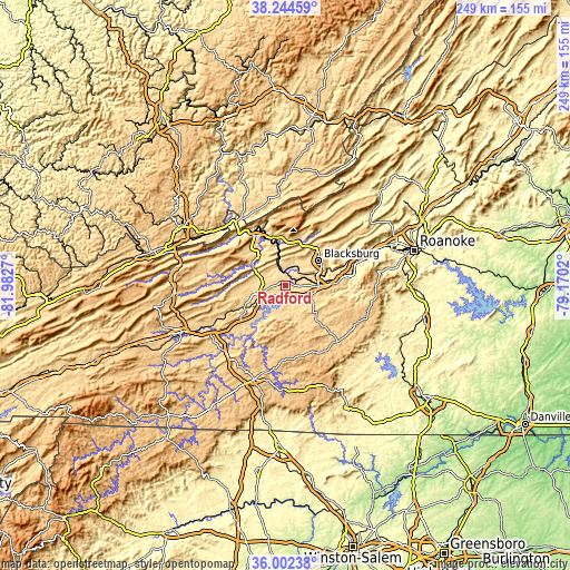
| \ | Map #1 | Map #2 | Topo.Map |
| Scale [m] | 516..707 m | 507..709 m | × |
| Scale [ft] | 1693..2320 ft | 1663..2326 ft | × |
| Average | 581.1 m = 1906 ft | 588.2 m = 1930 ft | × |
| Width | 7.79 km = 4.8 mi | 15.58 km = 9.7 mi | 249.3 km = 154.9 mi |
| Height | 7.79 km = 4.8 mi | 15.58 km = 9.7 mi | 249.3 km = 154.9 mi |
| ↑Max Latitude | 37.166817° | 37.201828° | 38.24459° |
| Latitude at center | 37.13179° | 37.13179° | 37.13179° |
| ↓Min Latitude | 37.096747° | 37.061687° | 36.00238° |
| ← Min Longitude | -80.620395° | -80.664341° | -81.9827° |
| Longitude center | -80.57645° | -80.57645° | -80.57645° |
| →Max Longitude | -80.532505° | -80.488559° | -79.1702° |
Nearby cities:
Cities around Radford sort by population:
• Blacksburg elevation 631 m
18 km,  52°
52°
• Christiansburg 637 m
14.9 km,  90°
90°
• Pulaski 582 m
20.3 km,  242°
242°
• Dublin 632 m
10.1 km,  253°
253°
• Pearisburg 557 m
25.9 km,  326°
326°
• Fairlawn 584 m
1.9 km,  354°
354°
• Merrimac 614 m
14.8 km,  64°
64°
• Narrows 475 m
30.4 km,  316°
316°
• Plum Creek 556 m
6.7 km, 91°
• Shawsville 433 m
28.8 km,  81°
81°
• Pembroke 503 m
21.6 km, 345°
• Prices Fork 619 m
11.6 km,  41°
41°
Multilingual:
 En español:
Radford elevación 570 m.
 En France:
Radford élévation 570 m.


Sources and notes:
- [note 1] Map square and city borders are not equal. Map elevation data is calculated only from area inside that square.
- [src 1] Elevation data from geonames database provided with same terms of usage.
- [src 2] The elevation map of Radford is generated using elevation data from NASA's 3 arcsec (90m) resolution SRTM data.
- [src 3] Base (background) map © OpenStreetMap contributors tiles are generated by Geofabrik and OpenTopoMap.
Copyright & License:
This Radford Elevation Map is licensed under CC BY-SA. You may reuse any part from this page, if you give a proper credit by linking to this URL:
 More info on terms of use page.