Merrimac elevation
Merrimac (Virginia, Montgomery County), United States elevation is 614 meters and Merrimac elevation in feet is 2014 ft above sea level [src 1]. Merrimac is a populated place (feature code) with elevation that is 335 meters (1099 ft) bigger than average city elevation in United States.
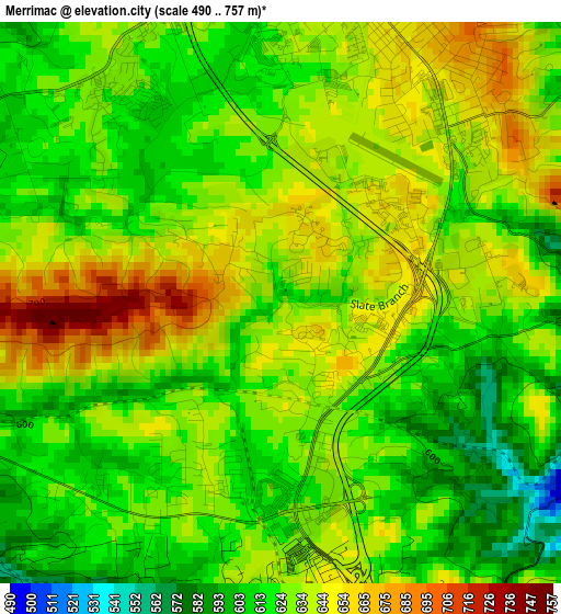
Below is the Elevation map of Merrimac, which displays elevation range with different colors. Scale of the first map is from 490 to 757 m (1608 to 2484 ft) with average elevation of 629.6 meters (=2066 ft) [note 1]
These maps also provides idea of topography and contour of this city, they are displayed at different zoom levels. More info about maps, scale and edge coordinates you can find below images.
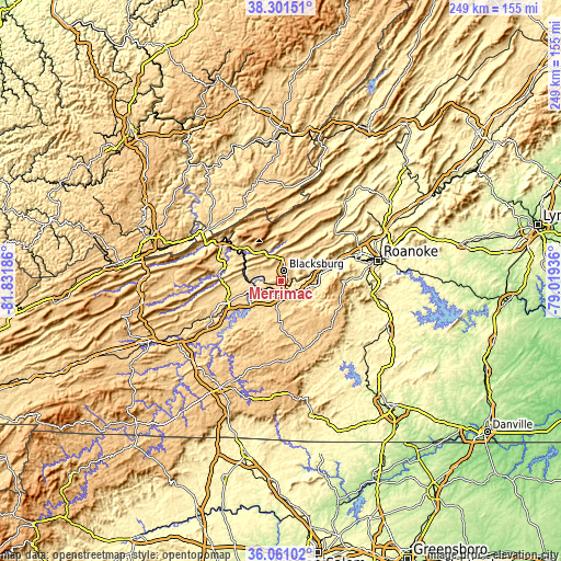
| \ | Map #1 | Topo.Map |
| Scale [m] | 490..757 m | × |
| Scale [ft] | 1608..2484 ft | × |
| Average | 629.6 m = 2066 ft | × |
| Width | 7.79 km = 4.8 mi | 249.1 km = 154.8 mi |
| Height | 7.79 km = 4.8 mi | 249.1 km = 154.8 mi |
| ↑Max Latitude | 37.22457° | 38.30151° |
| Latitude at center | 37.18957° | 37.18957° |
| ↓Min Latitude | 37.154553° | 36.06102° |
| ← Min Longitude | -80.469555° | -81.83186° |
| Longitude center | -80.42561° | -80.42561° |
| →Max Longitude | -80.381665° | -79.01936° |
Nearby cities:
Cities around Merrimac sort by population:
• Blacksburg elevation 631 m
4.6 km,  13°
13°
• Salem 326 m
34.8 km,  70°
70°
• Christiansburg 637 m
6.8 km,  167°
167°
• Radford 570 m
14.8 km,  244°
244°
• Dublin 632 m
24.8 km,  247°
247°
• Pearisburg 557 m
31.5 km,  298°
298°
• Fairlawn 584 m
14.3 km, 251°
• Plum Creek 556 m
9.4 km,  225°
225°
• Shawsville 433 m
15.3 km,  98°
98°
• Pembroke 503 m
23.8 km,  307°
307°
• Prices Fork 619 m
6.1 km,  291°
291°
• Floyd 756 m
32.3 km,  163°
163°
Multilingual:
 En español:
Merrimac elevación 614 m.
 En France:
Merrimac élévation 614 m.
 Auf Deutsch:
Merrimac höhe über dem Meeresspiegel ist 614 m.

Sources and notes:
- [note 1] Map square and city borders are not equal. Map elevation data is calculated only from area inside that square.
- [src 1] Elevation data from geonames database provided with same terms of usage.
- [src 2] The elevation map of Merrimac is generated using elevation data from NASA's 3 arcsec (90m) resolution SRTM data.
- [src 3] Base (background) map © OpenStreetMap contributors tiles are generated by Geofabrik and OpenTopoMap.
Copyright & License:
This Merrimac Elevation Map is licensed under CC BY-SA. You may reuse any part from this page, if you give a proper credit by linking to this URL:
 More info on terms of use page.