Wichita Falls elevation
Wichita Falls (Texas, Wichita County), United States elevation is 296 meters and Wichita Falls elevation in feet is 971 ft above sea level [src 1]. Wichita Falls is a seat of a second-order administrative division (feature code) with elevation that is 17 meters (56 ft) bigger than average city elevation in United States.
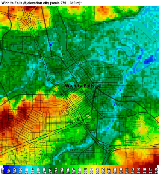
Below is the Elevation map of Wichita Falls, which displays elevation range with different colors. Scale of the first map is from 279 to 319 m (915 to 1047 ft) with average elevation of 295.4 meters (=969 ft) [note 1]
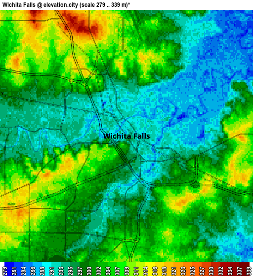
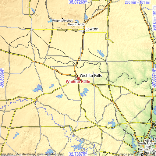
These maps also provides idea of topography and contour of this city, they are displayed at different zoom levels. More info about maps, scale and edge coordinates you can find below images.
| \ | Map #1 | Map #2 | Topo.Map |
| Scale [m] | 279..319 m | 279..339 m | × |
| Scale [ft] | 915..1047 ft | 915..1112 ft | × |
| Average | 295.4 m = 969 ft | 300.1 m = 985 ft | × |
| Width | 8.11 km = 5 mi | 16.22 km = 10.1 mi | 259.5 km = 161.2 mi |
| Height | 8.11 km = 5 mi | 16.22 km = 10.1 mi | 259.5 km = 161.2 mi |
| ↑Max Latitude | 33.950171° | 33.986617° | 35.07269° |
| Latitude at center | 33.91371° | 33.91371° | 33.91371° |
| ↓Min Latitude | 33.877233° | 33.84074° | 32.73875° |
| ← Min Longitude | -98.537335° | -98.581281° | -99.89964° |
| Longitude center | -98.49339° | -98.49339° | -98.49339° |
| →Max Longitude | -98.449445° | -98.405499° | -97.08714° |
Nearby cities:
Cities around Wichita Falls sort by population:
• Burkburnett elevation 327 m
21.7 km,  340°
340°
• Iowa Park 319 m
16.7 km,  284°
284°
• Bowie 350 m
71.5 km,  123°
123°
• Olney 367 m
65 km,  201°
201°
• Henrietta 283 m
29.5 km,  111°
111°
• Electra 378 m
41.3 km,  288°
288°
• Walters 309 m
52.5 km,  18°
18°
• Waurika 277 m
53.7 km,  58°
58°
• Archer City 331 m
37.4 km, 199°
• Holliday 325 m
21.5 km,  239°
239°
• Comanche 304 m
70.3 km,  43°
43°
• Geronimo 339 m
63.9 km,  9°
9°
Multilingual:
 En español:
Wichita Falls elevación 296 m.
 En France:
Wichita Falls élévation 296 m.
 Auf Deutsch:
Wichita Falls höhe über dem Meeresspiegel ist 296 m.

Sources and notes:
- [note 1] Map square and city borders are not equal. Map elevation data is calculated only from area inside that square.
- [src 1] Elevation data from geonames database provided with same terms of usage.
- [src 2] The elevation map of Wichita Falls is generated using elevation data from NASA's 3 arcsec (90m) resolution SRTM data.
- [src 3] Base (background) map © OpenStreetMap contributors tiles are generated by Geofabrik and OpenTopoMap.
Copyright & License:
This Wichita Falls Elevation Map is licensed under CC BY-SA. You may reuse any part from this page, if you give a proper credit by linking to this URL:
 More info on terms of use page.