Electra elevation
Electra (Texas, Wichita County), United States elevation is 378 meters and Electra elevation in feet is 1240 ft above sea level [src 1]. Electra is a populated place (feature code) with elevation that is 99 meters (325 ft) bigger than average city elevation in United States.
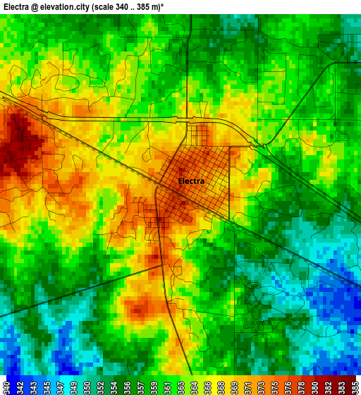
Below is the Elevation map of Electra, which displays elevation range with different colors. Scale of the first map is from 340 to 385 m (1115 to 1263 ft) with average elevation of 361.1 meters (=1185 ft) [note 1]
These maps also provides idea of topography and contour of this city, they are displayed at different zoom levels. More info about maps, scale and edge coordinates you can find below images.
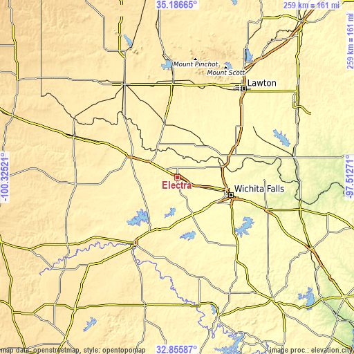
| \ | Map #1 | Topo.Map |
| Scale [m] | 340..385 m | × |
| Scale [ft] | 1115..1263 ft | × |
| Average | 361.1 m = 1185 ft | × |
| Width | 8.1 km = 5 mi | 259.2 km = 161.1 mi |
| Height | 8.1 km = 5 mi | 259.2 km = 161.1 mi |
| ↑Max Latitude | 34.065672° | 35.18665° |
| Latitude at center | 34.02926° | 34.02926° |
| ↓Min Latitude | 33.992832° | 32.85587° |
| ← Min Longitude | -98.962905° | -100.32521° |
| Longitude center | -98.91896° | -98.91896° |
| →Max Longitude | -98.875015° | -97.51271° |
Nearby cities:
Cities around Electra sort by population:
• Wichita Falls elevation 296 m
41.3 km,  108°
108°
• Burkburnett 327 m
33 km,  76°
76°
• Vernon 361 m
34.9 km,  293°
293°
• Iowa Park 319 m
24.6 km, 110°
• Frederick 402 m
41.4 km,  347°
347°
• Henrietta 283 m
70.8 km, 109°
• Seymour 399 m
57.7 km,  213°
213°
• Walters 309 m
67.2 km,  56°
56°
• Archer City 331 m
55.3 km,  150°
150°
• Holliday 325 m
31.4 km,  138°
138°
• Snyder 417 m
70.1 km,  357°
357°
• Geronimo 339 m
70.4 km,  44°
44°
Multilingual:
 En español:
Electra elevación 378 m.
 En France:
Electra élévation 378 m.


Sources and notes:
- [note 1] Map square and city borders are not equal. Map elevation data is calculated only from area inside that square.
- [src 1] Elevation data from geonames database provided with same terms of usage.
- [src 2] The elevation map of Electra is generated using elevation data from NASA's 3 arcsec (90m) resolution SRTM data.
- [src 3] Base (background) map © OpenStreetMap contributors tiles are generated by Geofabrik and OpenTopoMap.
Copyright & License:
This Electra Elevation Map is licensed under CC BY-SA. You may reuse any part from this page, if you give a proper credit by linking to this URL:
 More info on terms of use page.