Weimar elevation
Weimar (Texas, Colorado County), United States elevation is 129 meters and Weimar elevation in feet is 423 ft above sea level [src 1]. Weimar is a populated place (feature code) with elevation that is 150 meters (492 ft) smaller than average city elevation in United States.
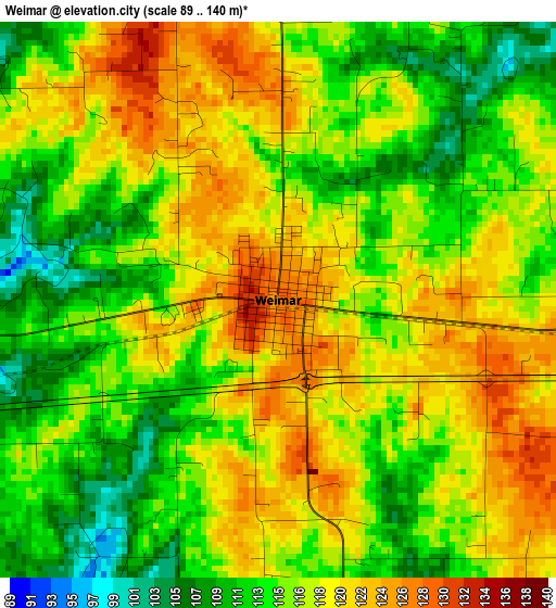
Below is the Elevation map of Weimar, which displays elevation range with different colors. Scale of the first map is from 89 to 140 m (292 to 459 ft) with average elevation of 116.6 meters (=383 ft) [note 1]
These maps also provides idea of topography and contour of this city, they are displayed at different zoom levels. More info about maps, scale and edge coordinates you can find below images.
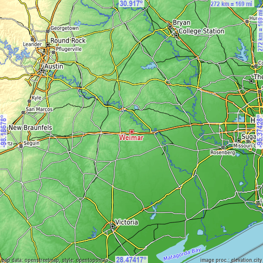
| \ | Map #1 | Topo.Map |
| Scale [m] | 89..140 m | × |
| Scale [ft] | 292..459 ft | × |
| Average | 116.6 m = 383 ft | × |
| Width | 8.49 km = 5.3 mi | 271.6 km = 168.8 mi |
| Height | 8.49 km = 5.3 mi | 271.6 km = 168.8 mi |
| ↑Max Latitude | 29.741174° | 30.917° |
| Latitude at center | 29.70301° | 29.70301° |
| ↓Min Latitude | 29.664832° | 28.47417° |
| ← Min Longitude | -96.824475° | -98.18678° |
| Longitude center | -96.78053° | -96.78053° |
| →Max Longitude | -96.736585° | -95.37428° |
Nearby cities:
Cities around Weimar sort by population:
• Sealy elevation 64 m
60.8 km,  81°
81°
• Yoakum 101 m
58.5 km,  217°
217°
• Giddings 157 m
55.4 km,  344°
344°
• La Grange 83 m
24.3 km, 337°
• Bellville 92 m
57.5 km,  61°
61°
• Smithville 104 m
49.9 km,  312°
312°
• Eagle Lake 57 m
45 km,  106°
106°
• Columbus 68 m
23.3 km,  89°
89°
• Schulenburg 114 m
12.1 km,  258°
258°
• Hallettsville 76 m
32.7 km,  208°
208°
• Shiner 113 m
48.5 km,  231°
231°
• Flatonia 142 m
31.7 km,  266°
266°
Multilingual:
 En español:
Weimar elevación 129 m.
 En France:
Weimar élévation 129 m.


Sources and notes:
- [note 1] Map square and city borders are not equal. Map elevation data is calculated only from area inside that square.
- [src 1] Elevation data from geonames database provided with same terms of usage.
- [src 2] The elevation map of Weimar is generated using elevation data from NASA's 3 arcsec (90m) resolution SRTM data.
- [src 3] Base (background) map © OpenStreetMap contributors tiles are generated by Geofabrik and OpenTopoMap.
Copyright & License:
This Weimar Elevation Map is licensed under CC BY-SA. You may reuse any part from this page, if you give a proper credit by linking to this URL:
 More info on terms of use page.