Sealy elevation
Sealy (Texas, Austin County), United States elevation is 64 meters and Sealy elevation in feet is 210 ft above sea level [src 1]. Sealy is a populated place (feature code) with elevation that is 215 meters (705 ft) smaller than average city elevation in United States.
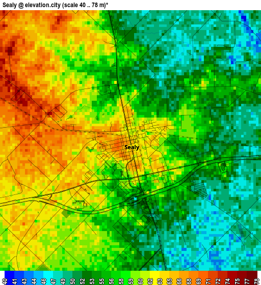
Below is the Elevation map of Sealy, which displays elevation range with different colors. Scale of the first map is from 40 to 78 m (131 to 256 ft) with average elevation of 57.5 meters (=189 ft) [note 1]
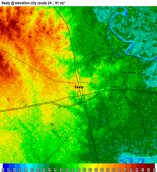
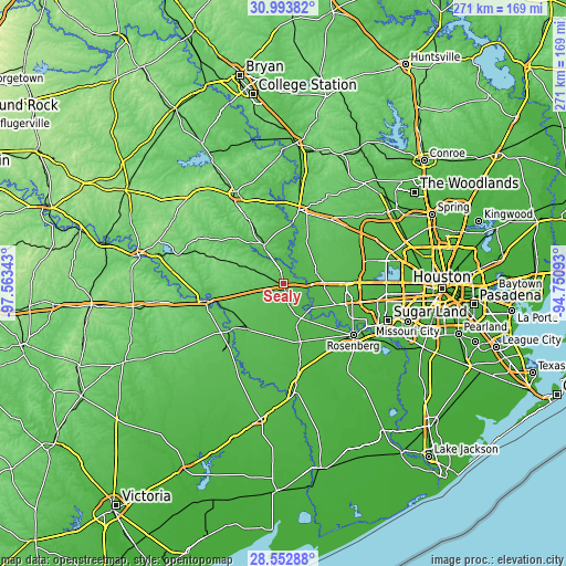
These maps also provides idea of topography and contour of this city, they are displayed at different zoom levels. More info about maps, scale and edge coordinates you can find below images.
| \ | Map #1 | Map #2 | Topo.Map |
| Scale [m] | 40..78 m | 24..91 m | × |
| Scale [ft] | 131..256 ft | 79..299 ft | × |
| Average | 57.5 m = 189 ft | 55.7 m = 183 ft | × |
| Width | 8.48 km = 5.3 mi | 16.96 km = 10.5 mi | 271.4 km = 168.6 mi |
| Height | 8.48 km = 5.3 mi | 16.96 km = 10.5 mi | 271.4 km = 168.6 mi |
| ↑Max Latitude | 29.818924° | 29.857044° | 30.99382° |
| Latitude at center | 29.78079° | 29.78079° | 29.78079° |
| ↓Min Latitude | 29.742641° | 29.704478° | 28.55288° |
| ← Min Longitude | -96.201125° | -96.245071° | -97.56343° |
| Longitude center | -96.15718° | -96.15718° | -96.15718° |
| →Max Longitude | -96.113235° | -96.069289° | -94.75093° |
Nearby cities:
Cities around Sealy sort by population:
• Katy elevation 44 m
32.1 km,  89°
89°
• Hempstead 77 m
36 km,  12°
12°
• Fulshear 43 m
26.8 km,  112°
112°
• Brookshire 54 m
19.9 km, 88°
• Bellville 92 m
21.2 km,  332°
332°
• Eagle Lake 57 m
27.2 km,  218°
218°
• Columbus 68 m
37.8 km,  257°
257°
• Weston Lakes 35 m
24 km,  116°
116°
• Waller 77 m
37.9 km,  35°
35°
• East Bernard 41 m
29 km,  163°
163°
• Wallis 41 m
18.8 km,  151°
151°
• Pine Island 65 m
32.9 km,  20°
20°
Multilingual:
 En español:
Sealy elevación 64 m.
 En France:
Sealy élévation 64 m.


Sources and notes:
- [note 1] Map square and city borders are not equal. Map elevation data is calculated only from area inside that square.
- [src 1] Elevation data from geonames database provided with same terms of usage.
- [src 2] The elevation map of Sealy is generated using elevation data from NASA's 3 arcsec (90m) resolution SRTM data.
- [src 3] Base (background) map © OpenStreetMap contributors tiles are generated by Geofabrik and OpenTopoMap.
Copyright & License:
This Sealy Elevation Map is licensed under CC BY-SA. You may reuse any part from this page, if you give a proper credit by linking to this URL:
 More info on terms of use page.