Teague elevation
Teague (Texas, Freestone County), United States elevation is 153 meters and Teague elevation in feet is 502 ft above sea level [src 1]. Teague is a populated place (feature code) with elevation that is 126 meters (413 ft) smaller than average city elevation in United States.
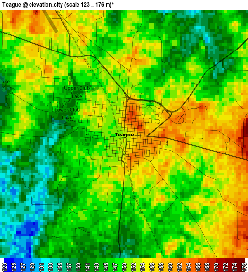
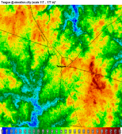
Below is the Elevation map of Teague, which displays elevation range with different colors. Scale of the first map is from 123 to 176 m (404 to 577 ft) with average elevation of 148.9 meters (=489 ft) [note 1]
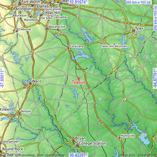
These maps also provides idea of topography and contour of this city, they are displayed at different zoom levels. More info about maps, scale and edge coordinates you can find below images.
| \ | Map #1 | Map #2 | Topo.Map |
| Scale [m] | 123..176 m | 117..177 m | × |
| Scale [ft] | 404..577 ft | 384..581 ft | × |
| Average | 148.9 m = 489 ft | 147.2 m = 483 ft | × |
| Width | 8.32 km = 5.2 mi | 16.64 km = 10.3 mi | 266.3 km = 165.5 mi |
| Height | 8.32 km = 5.2 mi | 16.64 km = 10.3 mi | 266.3 km = 165.5 mi |
| ↑Max Latitude | 31.664521° | 31.701917° | 32.81674° |
| Latitude at center | 31.62711° | 31.62711° | 31.62711° |
| ↓Min Latitude | 31.589684° | 31.552243° | 30.42207° |
| ← Min Longitude | -96.327805° | -96.371751° | -97.69011° |
| Longitude center | -96.28386° | -96.28386° | -96.28386° |
| →Max Longitude | -96.239915° | -96.195969° | -94.87761° |
Nearby cities:
Cities around Teague sort by population:
• Corsicana elevation 141 m
54.9 km,  341°
341°
• Mexia 164 m
19.7 km,  287°
287°
• Center 134 m
18.6 km,  225°
225°
• Groesbeck 152 m
26.3 km,  244°
244°
• Fairfield 142 m
15.6 km,  45°
45°
• Mart 164 m
52.9 km,  259°
259°
• Buffalo 120 m
28.1 km,  130°
130°
• Kerens 115 m
56.5 km,  5°
5°
• Hubbard 200 m
54.4 km,  296°
296°
• Jewett 152 m
32.4 km,  155°
155°
• Wortham 147 m
24.6 km,  316°
316°
• Centerville 109 m
50.2 km,  144°
144°
Multilingual:
 En español:
Teague elevación 153 m.
 En France:
Teague élévation 153 m.


Sources and notes:
- [note 1] Map square and city borders are not equal. Map elevation data is calculated only from area inside that square.
- [src 1] Elevation data from geonames database provided with same terms of usage.
- [src 2] The elevation map of Teague is generated using elevation data from NASA's 3 arcsec (90m) resolution SRTM data.
- [src 3] Base (background) map © OpenStreetMap contributors tiles are generated by Geofabrik and OpenTopoMap.
Copyright & License:
This Teague Elevation Map is licensed under CC BY-SA. You may reuse any part from this page, if you give a proper credit by linking to this URL:
 More info on terms of use page.