Mart elevation
Mart (Texas, McLennan County), United States elevation is 164 meters and Mart elevation in feet is 538 ft above sea level [src 1]. Mart is a populated place (feature code) with elevation that is 115 meters (377 ft) smaller than average city elevation in United States.
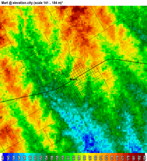
Below is the Elevation map of Mart, which displays elevation range with different colors. Scale of the first map is from 141 to 184 m (463 to 604 ft) with average elevation of 162.2 meters (=532 ft) [note 1]
These maps also provides idea of topography and contour of this city, they are displayed at different zoom levels. More info about maps, scale and edge coordinates you can find below images.
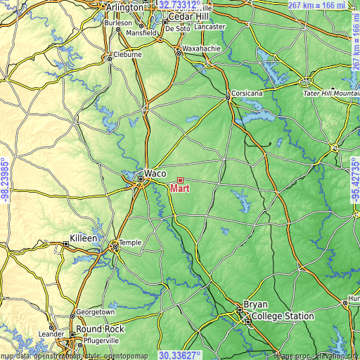
| \ | Map #1 | Topo.Map |
| Scale [m] | 141..184 m | × |
| Scale [ft] | 463..604 ft | × |
| Average | 162.2 m = 532 ft | × |
| Width | 8.33 km = 5.2 mi | 266.5 km = 165.6 mi |
| Height | 8.33 km = 5.2 mi | 266.5 km = 165.6 mi |
| ↑Max Latitude | 31.579835° | 32.73312° |
| Latitude at center | 31.54239° | 31.54239° |
| ↓Min Latitude | 31.50493° | 30.33627° |
| ← Min Longitude | -96.877545° | -98.23985° |
| Longitude center | -96.8336° | -96.8336° |
| →Max Longitude | -96.789655° | -95.42735° |
Nearby cities:
Cities around Mart sort by population:
• Waco elevation 147 m
29.7 km,  271°
271°
• Robinson 155 m
27.9 km,  252°
252°
• Bellmead 137 m
26.7 km,  282°
282°
• Woodway 196 m
35.4 km,  263°
263°
• Lacy-Lakeview 154 m
27.3 km,  290°
290°
• Marlin 126 m
27 km,  193°
193°
• Groesbeck 152 m
28.5 km,  94°
94°
• Beverly 152 m
29.3 km, 266°
• Beverly Hills 167 m
30.4 km, 265°
• Northcrest 154 m
27.3 km, 292°
• Hubbard 200 m
34.2 km,  5°
5°
• Riesel 158 m
11.3 km,  228°
228°
Multilingual:
 En español:
Mart elevación 164 m.
 En France:
Mart élévation 164 m.


Sources and notes:
- [note 1] Map square and city borders are not equal. Map elevation data is calculated only from area inside that square.
- [src 1] Elevation data from geonames database provided with same terms of usage.
- [src 2] The elevation map of Mart is generated using elevation data from NASA's 3 arcsec (90m) resolution SRTM data.
- [src 3] Base (background) map © OpenStreetMap contributors tiles are generated by Geofabrik and OpenTopoMap.
Copyright & License:
This Mart Elevation Map is licensed under CC BY-SA. You may reuse any part from this page, if you give a proper credit by linking to this URL:
 More info on terms of use page.