Kerens elevation
Kerens (Texas, Navarro County), United States elevation is 115 meters and Kerens elevation in feet is 377 ft above sea level [src 1]. Kerens is a populated place (feature code) with elevation that is 164 meters (538 ft) smaller than average city elevation in United States.
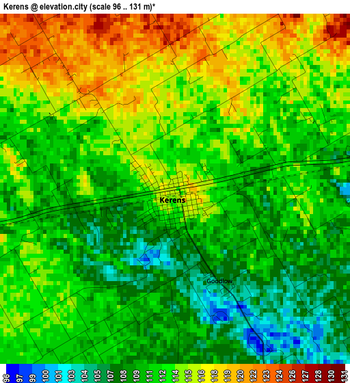
Below is the Elevation map of Kerens, which displays elevation range with different colors. Scale of the first map is from 96 to 131 m (315 to 430 ft) with average elevation of 112.3 meters (=368 ft) [note 1]
These maps also provides idea of topography and contour of this city, they are displayed at different zoom levels. More info about maps, scale and edge coordinates you can find below images.
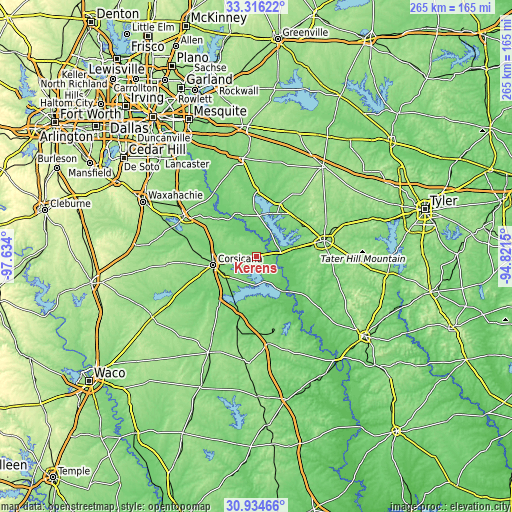
| \ | Map #1 | Topo.Map |
| Scale [m] | 96..131 m | × |
| Scale [ft] | 315..430 ft | × |
| Average | 112.3 m = 368 ft | × |
| Width | 8.28 km = 5.1 mi | 264.8 km = 164.5 mi |
| Height | 8.28 km = 5.1 mi | 264.8 km = 164.5 mi |
| ↑Max Latitude | 32.170416° | 33.31622° |
| Latitude at center | 32.13321° | 32.13321° |
| ↓Min Latitude | 32.095989° | 30.93466° |
| ← Min Longitude | -96.271695° | -97.634° |
| Longitude center | -96.22775° | -96.22775° |
| →Max Longitude | -96.183805° | -94.8215° |
Nearby cities:
Cities around Kerens sort by population:
• Corsicana elevation 141 m
23.1 km,  259°
259°
• Ennis 166 m
43.3 km,  300°
300°
• Athens 152 m
35.9 km,  77°
77°
• Kaufman 145 m
51.3 km,  351°
351°
• Gun Barrel City 117 m
23.5 km,  17°
17°
• Mabank 123 m
28.6 km, 24°
• Fairfield 142 m
45.8 km,  172°
172°
• Malakoff 119 m
20.7 km, 78°
• Tool 107 m
15.9 km, 19°
• Seven Points 120 m
20.9 km,  3°
3°
• Kemp 121 m
34.4 km,  359°
359°
• Wortham 147 m
44.3 km,  209°
209°
Multilingual:
 En español:
Kerens elevación 115 m.
 En France:
Kerens élévation 115 m.


Sources and notes:
- [note 1] Map square and city borders are not equal. Map elevation data is calculated only from area inside that square.
- [src 1] Elevation data from geonames database provided with same terms of usage.
- [src 2] The elevation map of Kerens is generated using elevation data from NASA's 3 arcsec (90m) resolution SRTM data.
- [src 3] Base (background) map © OpenStreetMap contributors tiles are generated by Geofabrik and OpenTopoMap.
Copyright & License:
This Kerens Elevation Map is licensed under CC BY-SA. You may reuse any part from this page, if you give a proper credit by linking to this URL:
 More info on terms of use page.