Ennis elevation
Ennis (Texas, Ellis County), United States elevation is 166 meters and Ennis elevation in feet is 545 ft above sea level [src 1]. Ennis is a populated place (feature code) with elevation that is 113 meters (371 ft) smaller than average city elevation in United States.
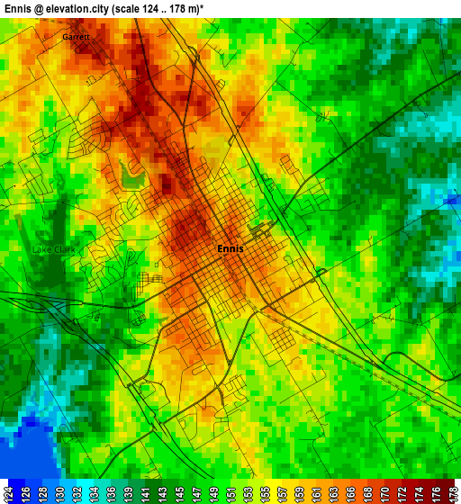
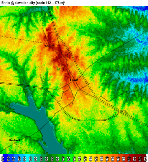
Below is the Elevation map of Ennis, which displays elevation range with different colors. Scale of the first map is from 124 to 178 m (407 to 584 ft) with average elevation of 152.1 meters (=499 ft) [note 1]
These maps also provides idea of topography and contour of this city, they are displayed at different zoom levels. More info about maps, scale and edge coordinates you can find below images.
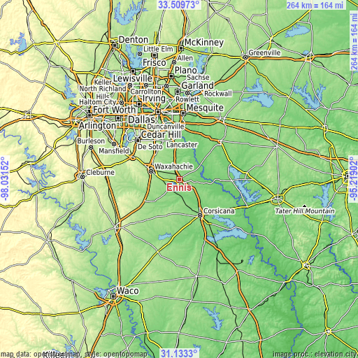
| \ | Map #1 | Map #2 | Topo.Map |
| Scale [m] | 124..178 m | 112..178 m | × |
| Scale [ft] | 407..584 ft | 367..584 ft | × |
| Average | 152.1 m = 499 ft | 143.9 m = 472 ft | × |
| Width | 8.26 km = 5.1 mi | 16.52 km = 10.3 mi | 264.2 km = 164.2 mi |
| Height | 8.26 km = 5.1 mi | 16.52 km = 10.3 mi | 264.2 km = 164.2 mi |
| ↑Max Latitude | 32.366436° | 32.403546° | 33.50973° |
| Latitude at center | 32.32931° | 32.32931° | 32.32931° |
| ↓Min Latitude | 32.292169° | 32.255013° | 31.1333° |
| ← Min Longitude | -96.669215° | -96.713161° | -98.03152° |
| Longitude center | -96.62527° | -96.62527° | -96.62527° |
| →Max Longitude | -96.581325° | -96.537379° | -95.21902° |
Nearby cities:
Cities around Ennis sort by population:
• Lancaster elevation 161 m
31.7 km,  337°
337°
• Waxahachie 174 m
21.9 km,  286°
286°
• Corsicana 141 m
29.9 km,  150°
150°
• Glenn Heights 206 m
32.7 km,  318°
318°
• Red Oak 190 m
26.9 km, 321°
• Wilmer 146 m
29.4 km,  348°
348°
• Ferris 146 m
23.1 km, 350°
• Nash 164 m
19 km,  248°
248°
• Combine 132 m
30.8 km,  20°
20°
• Palmer 144 m
12 km, 340°
• Italy 175 m
29.3 km,  236°
236°
• Oak Leaf 187 m
30.3 km,  314°
314°
Multilingual:
 En español:
Ennis elevación 166 m.
 En France:
Ennis élévation 166 m.


Sources and notes:
- [note 1] Map square and city borders are not equal. Map elevation data is calculated only from area inside that square.
- [src 1] Elevation data from geonames database provided with same terms of usage.
- [src 2] The elevation map of Ennis is generated using elevation data from NASA's 3 arcsec (90m) resolution SRTM data.
- [src 3] Base (background) map © OpenStreetMap contributors tiles are generated by Geofabrik and OpenTopoMap.
Copyright & License:
This Ennis Elevation Map is licensed under CC BY-SA. You may reuse any part from this page, if you give a proper credit by linking to this URL:
 More info on terms of use page.