Corrigan elevation
Corrigan (Texas, Polk County), United States elevation is 76 meters and Corrigan elevation in feet is 249 ft above sea level [src 1]. Corrigan is a populated place (feature code) with elevation that is 203 meters (666 ft) smaller than average city elevation in United States.
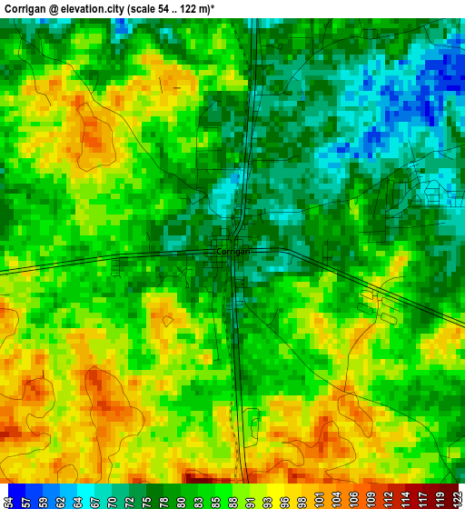
Below is the Elevation map of Corrigan, which displays elevation range with different colors. Scale of the first map is from 54 to 122 m (177 to 400 ft) with average elevation of 84.3 meters (=277 ft) [note 1]
These maps also provides idea of topography and contour of this city, they are displayed at different zoom levels. More info about maps, scale and edge coordinates you can find below images.
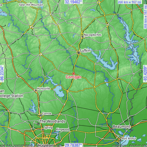
| \ | Map #1 | Topo.Map |
| Scale [m] | 54..122 m | × |
| Scale [ft] | 177..400 ft | × |
| Average | 84.3 m = 277 ft | × |
| Width | 8.38 km = 5.2 mi | 268.1 km = 166.6 mi |
| Height | 8.38 km = 5.2 mi | 268.1 km = 166.6 mi |
| ↑Max Latitude | 31.034522° | 32.19462° |
| Latitude at center | 30.99686° | 30.99686° |
| ↓Min Latitude | 30.959183° | 29.78387° |
| ← Min Longitude | -94.871095° | -96.2334° |
| Longitude center | -94.82715° | -94.82715° |
| →Max Longitude | -94.783205° | -93.4209° |
Nearby cities:
Cities around Corrigan sort by population:
• Lufkin elevation 99 m
39.1 km,  13°
13°
• West Livingston 46 m
37.2 km,  206°
206°
• Diboll 68 m
21.6 km, 11°
• Livingston 58 m
33.3 km,  197°
197°
• Hudson 107 m
36.5 km, 7°
• Trinity 74 m
52.6 km,  263°
263°
• Woodville 86 m
46.4 km,  122°
122°
• Huntington 103 m
39.3 km,  37°
37°
• Onalaska 60 m
34.8 km,  232°
232°
• Redland 111 m
46.4 km, 12°
• Groveton 102 m
29.2 km,  282°
282°
• Coldspring 114 m
53.4 km, 212°
Multilingual:
 En español:
Corrigan elevación 76 m.
 En France:
Corrigan élévation 76 m.


Sources and notes:
- [note 1] Map square and city borders are not equal. Map elevation data is calculated only from area inside that square.
- [src 1] Elevation data from geonames database provided with same terms of usage.
- [src 2] The elevation map of Corrigan is generated using elevation data from NASA's 3 arcsec (90m) resolution SRTM data.
- [src 3] Base (background) map © OpenStreetMap contributors tiles are generated by Geofabrik and OpenTopoMap.
Copyright & License:
This Corrigan Elevation Map is licensed under CC BY-SA. You may reuse any part from this page, if you give a proper credit by linking to this URL:
 More info on terms of use page.