Woodville elevation
Woodville (Texas, Tyler County), United States elevation is 86 meters and Woodville elevation in feet is 282 ft above sea level [src 1]. Woodville is a seat of a second-order administrative division (feature code) with elevation that is 193 meters (633 ft) smaller than average city elevation in United States.
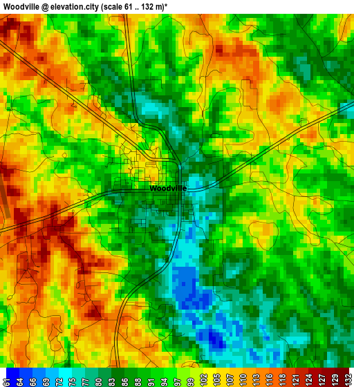
Below is the Elevation map of Woodville, which displays elevation range with different colors. Scale of the first map is from 61 to 132 m (200 to 433 ft) with average elevation of 96.4 meters (=316 ft) [note 1]
These maps also provides idea of topography and contour of this city, they are displayed at different zoom levels. More info about maps, scale and edge coordinates you can find below images.
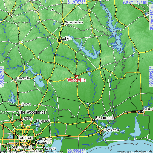
| \ | Map #1 | Topo.Map |
| Scale [m] | 61..132 m | × |
| Scale [ft] | 200..433 ft | × |
| Average | 96.4 m = 316 ft | × |
| Width | 8.4 km = 5.2 mi | 268.7 km = 167 mi |
| Height | 8.4 km = 5.2 mi | 268.7 km = 167 mi |
| ↑Max Latitude | 30.81295° | 31.97578° |
| Latitude at center | 30.7752° | 30.7752° |
| ↓Min Latitude | 30.737436° | 29.55945° |
| ← Min Longitude | -94.459425° | -95.82173° |
| Longitude center | -94.41548° | -94.41548° |
| →Max Longitude | -94.371535° | -93.00923° |
Nearby cities:
Cities around Woodville sort by population:
• West Livingston elevation 46 m
56.7 km,  261°
261°
• Jasper 65 m
43.1 km,  68°
68°
• Silsbee 27 m
52.6 km,  154°
154°
• Diboll 68 m
57.6 km,  322°
322°
• Livingston 58 m
50 km, 261°
• Buna 27 m
57.7 km,  131°
131°
• Kirbyville 40 m
51.6 km,  104°
104°
• Kountze 32 m
45.9 km,  167°
167°
• Corrigan 76 m
46.4 km,  302°
302°
• Evadale 16 m
57.1 km,  144°
144°
• Wildwood 44 m
28 km,  185°
185°
• Sam Rayburn 67 m
48.4 km,  48°
48°
Multilingual:
 En español:
Woodville elevación 86 m.
 En France:
Woodville élévation 86 m.
 Auf Deutsch:
Woodville höhe über dem Meeresspiegel ist 86 m.

Sources and notes:
- [note 1] Map square and city borders are not equal. Map elevation data is calculated only from area inside that square.
- [src 1] Elevation data from geonames database provided with same terms of usage.
- [src 2] The elevation map of Woodville is generated using elevation data from NASA's 3 arcsec (90m) resolution SRTM data.
- [src 3] Base (background) map © OpenStreetMap contributors tiles are generated by Geofabrik and OpenTopoMap.
Copyright & License:
This Woodville Elevation Map is licensed under CC BY-SA. You may reuse any part from this page, if you give a proper credit by linking to this URL:
 More info on terms of use page.