Coldspring elevation
Coldspring (Texas, San Jacinto County), United States elevation is 114 meters and Coldspring elevation in feet is 374 ft above sea level [src 1]. Coldspring is a seat of a second-order administrative division (feature code) with elevation that is 165 meters (541 ft) smaller than average city elevation in United States.
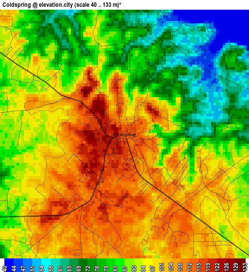
Below is the Elevation map of Coldspring, which displays elevation range with different colors. Scale of the first map is from 40 to 133 m (131 to 436 ft) with average elevation of 91.1 meters (=299 ft) [note 1]
These maps also provides idea of topography and contour of this city, they are displayed at different zoom levels. More info about maps, scale and edge coordinates you can find below images.
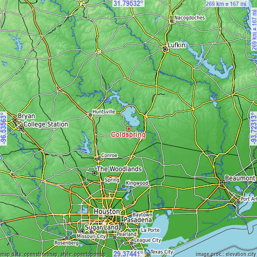
| \ | Map #1 | Topo.Map |
| Scale [m] | 40..133 m | × |
| Scale [ft] | 131..436 ft | × |
| Average | 91.1 m = 299 ft | × |
| Width | 8.41 km = 5.2 mi | 269.2 km = 167.3 mi |
| Height | 8.41 km = 5.2 mi | 269.2 km = 167.3 mi |
| ↑Max Latitude | 30.630241° | 31.79532° |
| Latitude at center | 30.59242° | 30.59242° |
| ↓Min Latitude | 30.554584° | 29.37441° |
| ← Min Longitude | -95.173325° | -96.53563° |
| Longitude center | -95.12938° | -95.12938° |
| →Max Longitude | -95.085435° | -93.72313° |
Nearby cities:
Cities around Coldspring sort by population:
• Conroe elevation 69 m
44.2 km,  225°
225°
• Huntsville 116 m
42.9 km,  289°
289°
• West Livingston 46 m
16.9 km,  46°
46°
• Cleveland 54 m
28.2 km,  171°
171°
• Willis 119 m
38.4 km,  240°
240°
• Livingston 58 m
23 km, 54°
• Shepherd 49 m
16.5 km,  129°
129°
• Panorama Village 101 m
42.1 km, 236°
• Onalaska 60 m
23.8 km,  3°
3°
• Splendora 42 m
40.1 km,  184°
184°
• Cut and Shoot 61 m
36.2 km,  217°
217°
• New Waverly 111 m
34.4 km,  259°
259°
Multilingual:
 En español:
Coldspring elevación 114 m.
 En France:
Coldspring élévation 114 m.
 Auf Deutsch:
Coldspring höhe über dem Meeresspiegel ist 114 m.

Sources and notes:
- [note 1] Map square and city borders are not equal. Map elevation data is calculated only from area inside that square.
- [src 1] Elevation data from geonames database provided with same terms of usage.
- [src 2] The elevation map of Coldspring is generated using elevation data from NASA's 3 arcsec (90m) resolution SRTM data.
- [src 3] Base (background) map © OpenStreetMap contributors tiles are generated by Geofabrik and OpenTopoMap.
Copyright & License:
This Coldspring Elevation Map is licensed under CC BY-SA. You may reuse any part from this page, if you give a proper credit by linking to this URL:
 More info on terms of use page.