Coleman elevation
Coleman (Texas, Coleman County), United States elevation is 521 meters and Coleman elevation in feet is 1709 ft above sea level [src 1]. Coleman is a seat of a second-order administrative division (feature code) with elevation that is 242 meters (794 ft) bigger than average city elevation in United States.
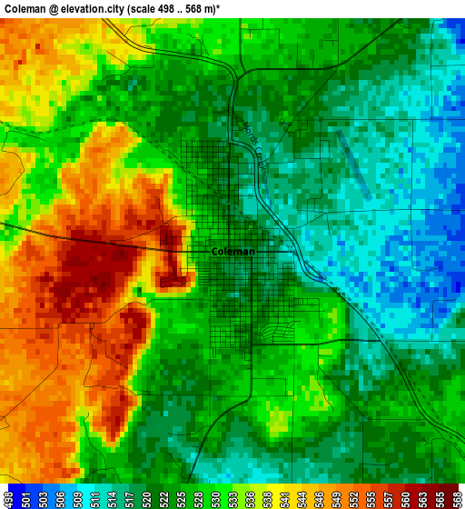
Below is the Elevation map of Coleman, which displays elevation range with different colors. Scale of the first map is from 498 to 568 m (1634 to 1864 ft) with average elevation of 528.2 meters (=1733 ft) [note 1]
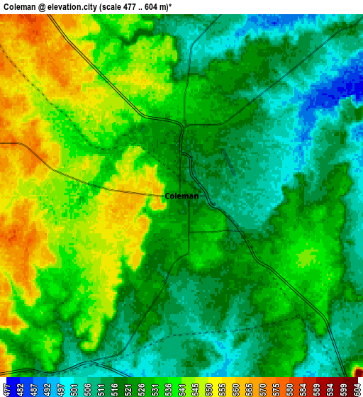
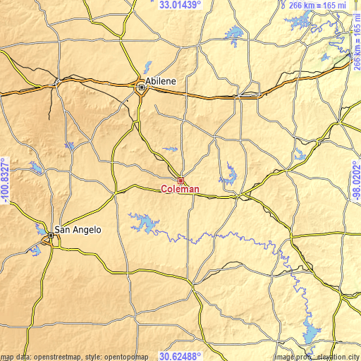
These maps also provides idea of topography and contour of this city, they are displayed at different zoom levels. More info about maps, scale and edge coordinates you can find below images.
| \ | Map #1 | Map #2 | Topo.Map |
| Scale [m] | 498..568 m | 477..604 m | × |
| Scale [ft] | 1634..1864 ft | 1565..1982 ft | × |
| Average | 528.2 m = 1733 ft | 527.5 m = 1731 ft | × |
| Width | 8.3 km = 5.2 mi | 16.61 km = 10.3 mi | 265.7 km = 165.1 mi |
| Height | 8.3 km = 5.2 mi | 16.61 km = 10.3 mi | 265.7 km = 165.1 mi |
| ↑Max Latitude | 31.8647° | 31.902015° | 33.01439° |
| Latitude at center | 31.82737° | 31.82737° | 31.82737° |
| ↓Min Latitude | 31.790025° | 31.752664° | 30.62488° |
| ← Min Longitude | -99.470395° | -99.514341° | -100.8327° |
| Longitude center | -99.42645° | -99.42645° | -99.42645° |
| →Max Longitude | -99.382505° | -99.338559° | -98.0202° |
Nearby cities:
Cities around Coleman sort by population:
• Abilene elevation 525 m
74.9 km,  337°
337°
• Brownwood 420 m
43.2 km,  107°
107°
• Clyde 608 m
64.6 km,  354°
354°
• Ballinger 499 m
50.2 km,  258°
258°
• Potosi 557 m
59.9 km, 338°
• Early 430 m
46.4 km,  101°
101°
• Winters 564 m
52.6 km,  285°
285°
• Bangs 495 m
30.4 km, 113°
• Lake Brownwood 446 m
39.6 km,  88°
88°
• Baird 524 m
63.1 km,  2°
2°
• Santa Anna 540 m
13.7 km,  133°
133°
• Paint Rock 499 m
58.6 km,  232°
232°
Multilingual:
 En español:
Coleman elevación 521 m.
 En France:
Coleman élévation 521 m.


Sources and notes:
- [note 1] Map square and city borders are not equal. Map elevation data is calculated only from area inside that square.
- [src 1] Elevation data from geonames database provided with same terms of usage.
- [src 2] The elevation map of Coleman is generated using elevation data from NASA's 3 arcsec (90m) resolution SRTM data.
- [src 3] Base (background) map © OpenStreetMap contributors tiles are generated by Geofabrik and OpenTopoMap.
Copyright & License:
This Coleman Elevation Map is licensed under CC BY-SA. You may reuse any part from this page, if you give a proper credit by linking to this URL:
 More info on terms of use page.