Arlington elevation
Arlington (Texas, Tarrant County), United States elevation is 190 meters and Arlington elevation in feet is 623 ft above sea level [src 1]. Arlington is a populated place (feature code) with elevation that is 89 meters (292 ft) smaller than average city elevation in United States.
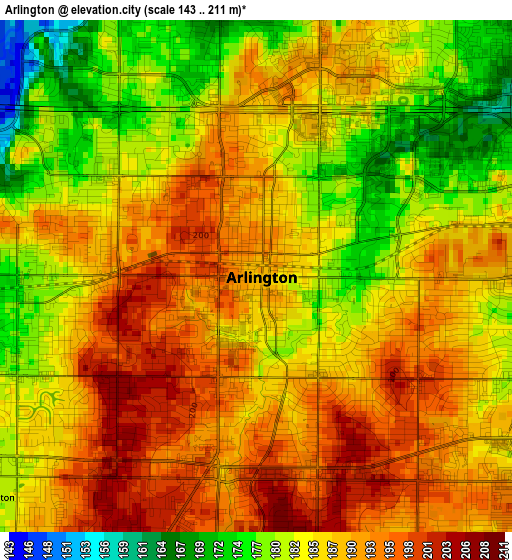
Below is the Elevation map of Arlington, which displays elevation range with different colors. Scale of the first map is from 143 to 211 m (469 to 692 ft) with average elevation of 186.7 meters (=613 ft) [note 1]
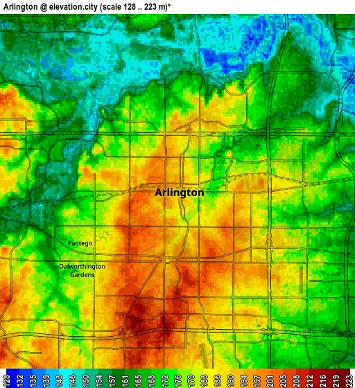
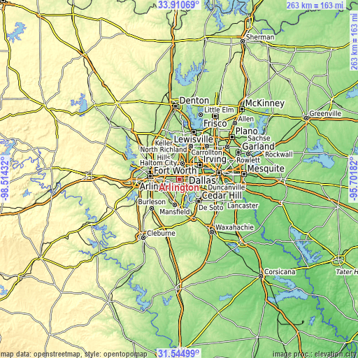
These maps also provides idea of topography and contour of this city, they are displayed at different zoom levels. More info about maps, scale and edge coordinates you can find below images.
| \ | Map #1 | Map #2 | Topo.Map |
| Scale [m] | 143..211 m | 128..223 m | × |
| Scale [ft] | 469..692 ft | 420..732 ft | × |
| Average | 186.7 m = 613 ft | 174.3 m = 572 ft | × |
| Width | 8.22 km = 5.1 mi | 16.44 km = 10.2 mi | 263 km = 163.4 mi |
| Height | 8.22 km = 5.1 mi | 16.44 km = 10.2 mi | 263 km = 163.4 mi |
| ↑Max Latitude | 32.772648° | 32.809591° | 33.91069° |
| Latitude at center | 32.73569° | 32.73569° | 32.73569° |
| ↓Min Latitude | 32.698717° | 32.661728° | 31.54499° |
| ← Min Longitude | -97.152015° | -97.195961° | -98.51432° |
| Longitude center | -97.10807° | -97.10807° | -97.10807° |
| →Max Longitude | -97.064125° | -97.020179° | -95.70182° |
Nearby cities:
Cities around Arlington sort by population:
• Grand Prairie elevation 162 m
10.4 km,  83°
83°
• North Richland Hills 188 m
15.7 km,  314°
314°
• Euless 184 m
11.5 km,  12°
12°
• Bedford 187 m
12.5 km,  344°
344°
• Haltom City 166 m
16.7 km,  295°
295°
• Hurst 174 m
11.4 km,  329°
329°
• Colleyville 190 m
16.7 km, 344°
• Forest Hill 215 m
16.7 km,  244°
244°
• Richland Hills 178 m
14.3 km, 308°
• Kennedale 197 m
14.8 km,  228°
228°
• Pantego 177 m
5.1 km, 242°
• Dalworthington Gardens 180 m
5.7 km, 230°
Multilingual:
 En español:
Arlington elevación 190 m.
 En France:
Arlington élévation 190 m.
 Auf Deutsch:
Arlington höhe über dem Meeresspiegel ist 190 m.

Sources and notes:
- [note 1] Map square and city borders are not equal. Map elevation data is calculated only from area inside that square.
- [src 1] Elevation data from geonames database provided with same terms of usage.
- [src 2] The elevation map of Arlington is generated using elevation data from NASA's 3 arcsec (90m) resolution SRTM data.
- [src 3] Base (background) map © OpenStreetMap contributors tiles are generated by Geofabrik and OpenTopoMap.
Copyright & License:
This Arlington Elevation Map is licensed under CC BY-SA. You may reuse any part from this page, if you give a proper credit by linking to this URL:
 More info on terms of use page.