Colleyville elevation
Colleyville (Texas, Tarrant County), United States elevation is 190 meters and Colleyville elevation in feet is 623 ft above sea level [src 1]. Colleyville is a populated place (feature code) with elevation that is 89 meters (292 ft) smaller than average city elevation in United States.
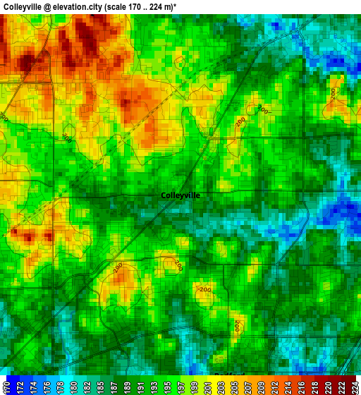
Below is the Elevation map of Colleyville, which displays elevation range with different colors. Scale of the first map is from 170 to 224 m (558 to 735 ft) with average elevation of 193.6 meters (=635 ft) [note 1]
These maps also provides idea of topography and contour of this city, they are displayed at different zoom levels. More info about maps, scale and edge coordinates you can find below images.
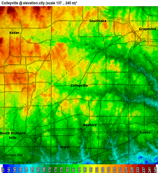
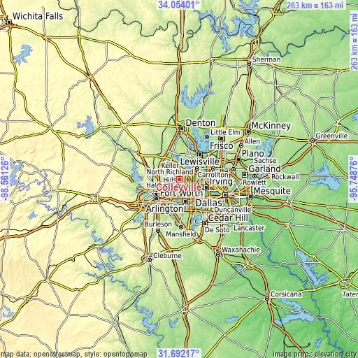
| \ | Map #1 | Map #2 | Topo.Map |
| Scale [m] | 170..224 m | 137..245 m | × |
| Scale [ft] | 558..735 ft | 449..804 ft | × |
| Average | 193.6 m = 635 ft | 190.9 m = 626 ft | × |
| Width | 8.21 km = 5.1 mi | 16.41 km = 10.2 mi | 262.6 km = 163.2 mi |
| Height | 8.21 km = 5.1 mi | 16.41 km = 10.2 mi | 262.6 km = 163.2 mi |
| ↑Max Latitude | 32.917858° | 32.95474° | 34.05401° |
| Latitude at center | 32.88096° | 32.88096° | 32.88096° |
| ↓Min Latitude | 32.844047° | 32.807119° | 31.69217° |
| ← Min Longitude | -97.198955° | -97.242901° | -98.56126° |
| Longitude center | -97.15501° | -97.15501° | -97.15501° |
| →Max Longitude | -97.111065° | -97.067119° | -95.74876° |
Nearby cities:
Cities around Colleyville sort by population:
• North Richland Hills elevation 188 m
8.6 km,  233°
233°
• Euless 184 m
8.4 km,  125°
125°
• Grapevine 199 m
9.3 km,  50°
50°
• Bedford 187 m
4.3 km,  164°
164°
• Keller 220 m
10.8 km,  303°
303°
• Haltom City 166 m
14 km, 229°
• Hurst 174 m
6.6 km,  192°
192°
• Southlake 197 m
7 km,  16°
16°
• Watauga 188 m
9.7 km,  254°
254°
• Trophy Club 190 m
13.3 km,  348°
348°
• Richland Hills 178 m
9.9 km,  223°
223°
• Westlake 206 m
12.8 km,  343°
343°
Multilingual:
 En español:
Colleyville elevación 190 m.
 En France:
Colleyville élévation 190 m.
 Auf Deutsch:
Colleyville höhe über dem Meeresspiegel ist 190 m.

Sources and notes:
- [note 1] Map square and city borders are not equal. Map elevation data is calculated only from area inside that square.
- [src 1] Elevation data from geonames database provided with same terms of usage.
- [src 2] The elevation map of Colleyville is generated using elevation data from NASA's 3 arcsec (90m) resolution SRTM data.
- [src 3] Base (background) map © OpenStreetMap contributors tiles are generated by Geofabrik and OpenTopoMap.
Copyright & License:
This Colleyville Elevation Map is licensed under CC BY-SA. You may reuse any part from this page, if you give a proper credit by linking to this URL:
 More info on terms of use page.