Grand Prairie elevation
Grand Prairie (Texas, Dallas County), United States elevation is 162 meters and Grand Prairie elevation in feet is 531 ft above sea level [src 1]. Grand Prairie is a populated place (feature code) with elevation that is 117 meters (384 ft) smaller than average city elevation in United States.
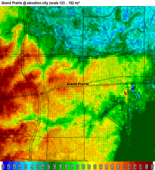
Below is the Elevation map of Grand Prairie, which displays elevation range with different colors. Scale of the first map is from 123 to 182 m (404 to 597 ft) with average elevation of 152.5 meters (=500 ft) [note 1]
These maps also provides idea of topography and contour of this city, they are displayed at different zoom levels. More info about maps, scale and edge coordinates you can find below images.
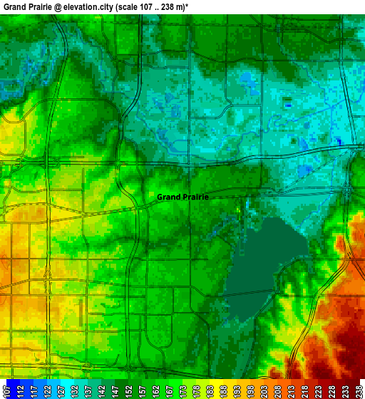
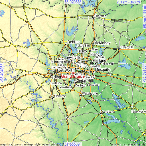
| \ | Map #1 | Map #2 | Topo.Map |
| Scale [m] | 123..182 m | 107..238 m | × |
| Scale [ft] | 404..597 ft | 351..781 ft | × |
| Average | 152.5 m = 500 ft | 159.3 m = 523 ft | × |
| Width | 8.22 km = 5.1 mi | 16.44 km = 10.2 mi | 263 km = 163.4 mi |
| Height | 8.22 km = 5.1 mi | 16.44 km = 10.2 mi | 263 km = 163.4 mi |
| ↑Max Latitude | 32.782914° | 32.819852° | 33.92083° |
| Latitude at center | 32.74596° | 32.74596° | 32.74596° |
| ↓Min Latitude | 32.708991° | 32.672007° | 31.55539° |
| ← Min Longitude | -97.041725° | -97.085671° | -98.40403° |
| Longitude center | -96.99778° | -96.99778° | -96.99778° |
| →Max Longitude | -96.953835° | -96.909889° | -95.59153° |
Nearby cities:
Cities around Grand Prairie sort by population:
• Dallas elevation 139 m
18.3 km,  77°
77°
• Arlington 190 m
10.4 km,  263°
263°
• Irving 151 m
8.8 km,  31°
31°
• Euless 184 m
12.8 km,  322°
322°
• Bedford 187 m
17.4 km,  308°
308°
• Cedar Hill 258 m
17.9 km,  167°
167°
• Duncanville 224 m
13.4 km,  141°
141°
• Hurst 174 m
18.3 km,  298°
298°
• Cockrell Hill 202 m
10.4 km,  95°
95°
• Pantego 177 m
15.2 km, 256°
• Dalworthington Gardens 180 m
15.5 km,  252°
252°
• Shamrock 216 m
19.3 km,  147°
147°
Multilingual:
 En español:
Grand Prairie elevación 162 m.
 En France:
Grand Prairie élévation 162 m.
 Auf Deutsch:
Grand Prairie höhe über dem Meeresspiegel ist 162 m.

Sources and notes:
- [note 1] Map square and city borders are not equal. Map elevation data is calculated only from area inside that square.
- [src 1] Elevation data from geonames database provided with same terms of usage.
- [src 2] The elevation map of Grand Prairie is generated using elevation data from NASA's 3 arcsec (90m) resolution SRTM data.
- [src 3] Base (background) map © OpenStreetMap contributors tiles are generated by Geofabrik and OpenTopoMap.
Copyright & License:
This Grand Prairie Elevation Map is licensed under CC BY-SA. You may reuse any part from this page, if you give a proper credit by linking to this URL:
 More info on terms of use page.