White Pine elevation
White Pine (Tennessee, Jefferson County), United States elevation is 347 meters and White Pine elevation in feet is 1138 ft above sea level [src 1]. White Pine is a populated place (feature code) with elevation that is 68 meters (223 ft) bigger than average city elevation in United States.
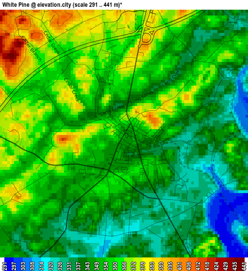
Below is the Elevation map of White Pine, which displays elevation range with different colors. Scale of the first map is from 291 to 441 m (955 to 1447 ft) with average elevation of 351.2 meters (=1152 ft) [note 1]
These maps also provides idea of topography and contour of this city, they are displayed at different zoom levels. More info about maps, scale and edge coordinates you can find below images.
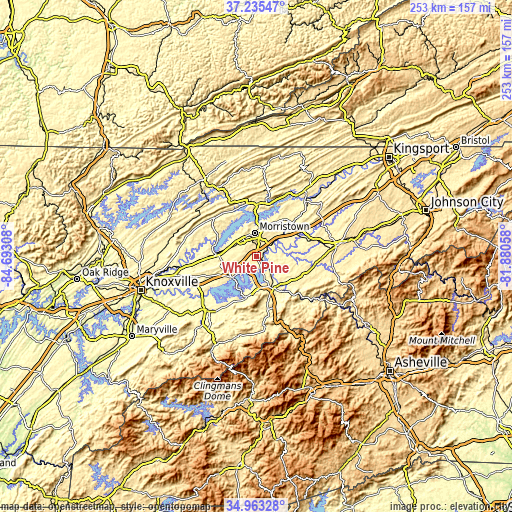
| \ | Map #1 | Topo.Map |
| Scale [m] | 291..441 m | × |
| Scale [ft] | 955..1447 ft | × |
| Average | 351.2 m = 1152 ft | × |
| Width | 7.9 km = 4.9 mi | 252.6 km = 157 mi |
| Height | 7.9 km = 4.9 mi | 252.6 km = 157 mi |
| ↑Max Latitude | 36.143086° | 37.23547° |
| Latitude at center | 36.10759° | 36.10759° |
| ↓Min Latitude | 36.072078° | 34.96328° |
| ← Min Longitude | -83.330775° | -84.69308° |
| Longitude center | -83.28683° | -83.28683° |
| →Max Longitude | -83.242885° | -81.88058° |
Nearby cities:
Cities around White Pine sort by population:
• Morristown elevation 399 m
11.9 km,  356°
356°
• Sevierville 275 m
36.3 km,  222°
222°
• Greeneville 469 m
41.4 km,  81°
81°
• Jefferson City 371 m
18.5 km,  275°
275°
• Newport 326 m
18 km,  150°
150°
• Bean Station 351 m
26.3 km,  0°
0°
• Dandridge 305 m
15.4 km,  228°
228°
• Mascot 266 m
41.6 km,  262°
262°
• Mosheim 390 m
30.9 km,  72°
72°
• Blaine 289 m
37.8 km, 277°
• New Market 327 m
23.9 km,  269°
269°
• Rutledge 309 m
28.1 km,  313°
313°
Multilingual:
 En español:
White Pine elevación 347 m.
 En France:
White Pine élévation 347 m.
 Auf Deutsch:
White Pine höhe über dem Meeresspiegel ist 347 m.

Sources and notes:
- [note 1] Map square and city borders are not equal. Map elevation data is calculated only from area inside that square.
- [src 1] Elevation data from geonames database provided with same terms of usage.
- [src 2] The elevation map of White Pine is generated using elevation data from NASA's 3 arcsec (90m) resolution SRTM data.
- [src 3] Base (background) map © OpenStreetMap contributors tiles are generated by Geofabrik and OpenTopoMap.
Copyright & License:
This White Pine Elevation Map is licensed under CC BY-SA. You may reuse any part from this page, if you give a proper credit by linking to this URL:
 More info on terms of use page.