Bean Station elevation
Bean Station (Tennessee, Grainger County), United States elevation is 351 meters and Bean Station elevation in feet is 1152 ft above sea level [src 1]. Bean Station is a populated place (feature code) with elevation that is 72 meters (236 ft) bigger than average city elevation in United States.
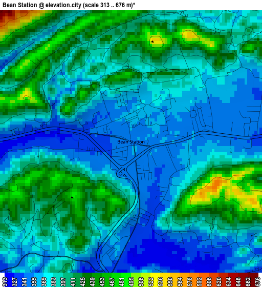
Below is the Elevation map of Bean Station, which displays elevation range with different colors. Scale of the first map is from 313 to 676 m (1027 to 2218 ft) with average elevation of 391.3 meters (=1284 ft) [note 1]
These maps also provides idea of topography and contour of this city, they are displayed at different zoom levels. More info about maps, scale and edge coordinates you can find below images.
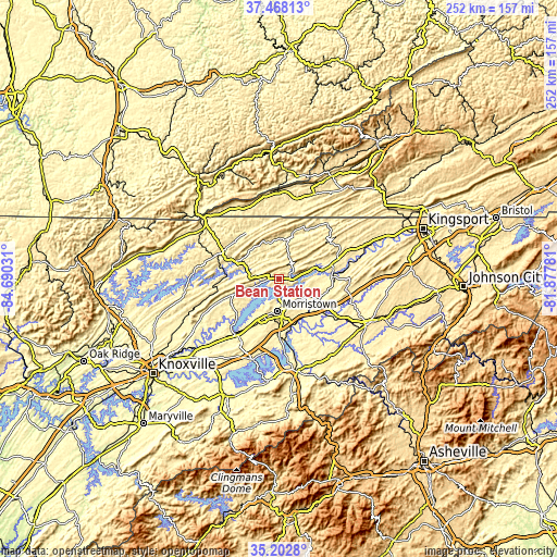
| \ | Map #1 | Topo.Map |
| Scale [m] | 313..676 m | × |
| Scale [ft] | 1027..2218 ft | × |
| Average | 391.3 m = 1284 ft | × |
| Width | 7.87 km = 4.9 mi | 251.9 km = 156.5 mi |
| Height | 7.87 km = 4.9 mi | 251.9 km = 156.5 mi |
| ↑Max Latitude | 36.379089° | 37.46813° |
| Latitude at center | 36.3437° | 36.3437° |
| ↓Min Latitude | 36.308295° | 35.2028° |
| ← Min Longitude | -83.328005° | -84.69031° |
| Longitude center | -83.28406° | -83.28406° |
| →Max Longitude | -83.240115° | -81.87781° |
Nearby cities:
Cities around Bean Station sort by population:
• Morristown elevation 399 m
14.5 km,  183°
183°
• Jefferson City 371 m
30.9 km,  217°
217°
• Rogersville 396 m
25.9 km,  74°
74°
• New Tazewell 450 m
30.3 km,  291°
291°
• Dandridge 305 m
38.3 km,  197°
197°
• Mosheim 390 m
33.8 km,  120°
120°
• Tazewell 417 m
28.3 km,  295°
295°
• White Pine 347 m
26.3 km, 180°
• Surgoinsville 347 m
41.2 km, 69°
• New Market 327 m
35.9 km, 222°
• Sneedville 360 m
21.5 km,  16°
16°
• Rutledge 309 m
21.8 km,  251°
251°
Multilingual:
 En español:
Bean Station elevación 351 m.
 En France:
Bean Station élévation 351 m.
 Auf Deutsch:
Bean Station höhe über dem Meeresspiegel ist 351 m.

Sources and notes:
- [note 1] Map square and city borders are not equal. Map elevation data is calculated only from area inside that square.
- [src 1] Elevation data from geonames database provided with same terms of usage.
- [src 2] The elevation map of Bean Station is generated using elevation data from NASA's 3 arcsec (90m) resolution SRTM data.
- [src 3] Base (background) map © OpenStreetMap contributors tiles are generated by Geofabrik and OpenTopoMap.
Copyright & License:
This Bean Station Elevation Map is licensed under CC BY-SA. You may reuse any part from this page, if you give a proper credit by linking to this URL:
 More info on terms of use page.