Rogersville elevation
Rogersville (Tennessee, Hawkins County), United States elevation is 396 meters and Rogersville elevation in feet is 1299 ft above sea level [src 1]. Rogersville is a seat of a second-order administrative division (feature code) with elevation that is 117 meters (384 ft) bigger than average city elevation in United States.
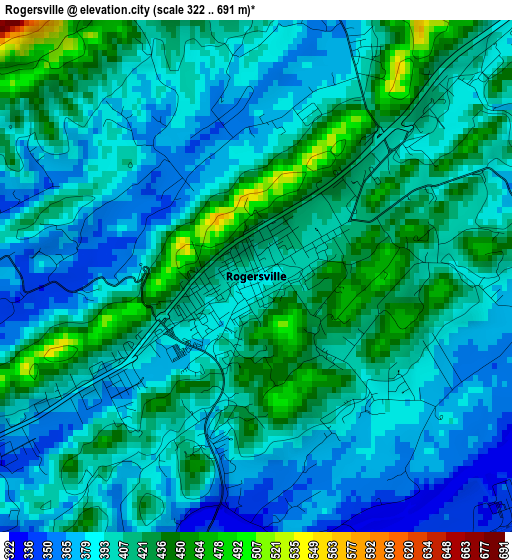
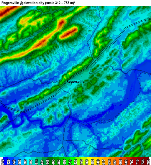
Below is the Elevation map of Rogersville, which displays elevation range with different colors. Scale of the first map is from 322 to 691 m (1056 to 2267 ft) with average elevation of 401.7 meters (=1318 ft) [note 1]
These maps also provides idea of topography and contour of this city, they are displayed at different zoom levels. More info about maps, scale and edge coordinates you can find below images.
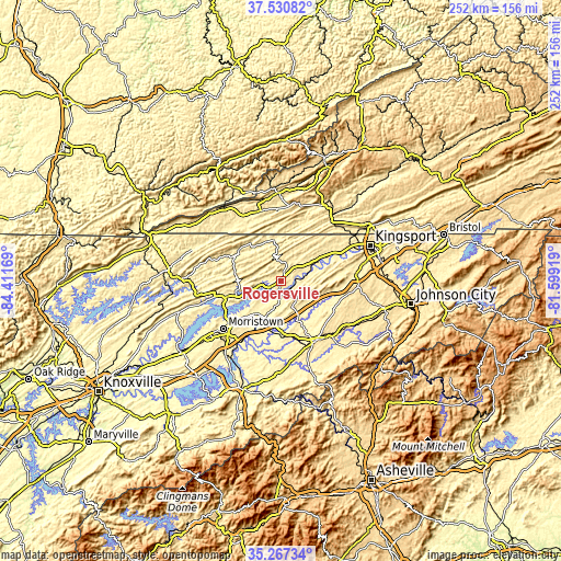
| \ | Map #1 | Map #2 | Topo.Map |
| Scale [m] | 322..691 m | 312..753 m | × |
| Scale [ft] | 1056..2267 ft | 1024..2470 ft | × |
| Average | 401.7 m = 1318 ft | 403.8 m = 1325 ft | × |
| Width | 7.87 km = 4.9 mi | 15.73 km = 9.8 mi | 251.7 km = 156.4 mi |
| Height | 7.87 km = 4.9 mi | 15.73 km = 9.8 mi | 251.7 km = 156.4 mi |
| ↑Max Latitude | 36.44268° | 36.478024° | 37.53082° |
| Latitude at center | 36.40732° | 36.40732° | 36.40732° |
| ↓Min Latitude | 36.371944° | 36.336552° | 35.26734° |
| ← Min Longitude | -83.049385° | -83.093331° | -84.41169° |
| Longitude center | -83.00544° | -83.00544° | -83.00544° |
| →Max Longitude | -82.961495° | -82.917549° | -81.59919° |
Nearby cities:
Cities around Rogersville sort by population:
• Morristown elevation 399 m
33.7 km,  230°
230°
• Greeneville 469 m
31.3 km,  150°
150°
• Church Hill 375 m
29.1 km,  63°
63°
• Mount Carmel 414 m
34.4 km, 63°
• Bean Station 351 m
25.9 km,  254°
254°
• Tusculum 455 m
34 km,  139°
139°
• Mosheim 390 m
24.6 km,  170°
170°
• Pennington Gap 421 m
39.1 km,  357°
357°
• Surgoinsville 347 m
15.5 km, 62°
• Sneedville 360 m
23.3 km,  305°
305°
• Fall Branch 457 m
34.2 km,  87°
87°
• Jonesville 460 m
32.7 km,  343°
343°
Multilingual:
 En español:
Rogersville elevación 396 m.
 En France:
Rogersville élévation 396 m.
 Auf Deutsch:
Rogersville höhe über dem Meeresspiegel ist 396 m.

Sources and notes:
- [note 1] Map square and city borders are not equal. Map elevation data is calculated only from area inside that square.
- [src 1] Elevation data from geonames database provided with same terms of usage.
- [src 2] The elevation map of Rogersville is generated using elevation data from NASA's 3 arcsec (90m) resolution SRTM data.
- [src 3] Base (background) map © OpenStreetMap contributors tiles are generated by Geofabrik and OpenTopoMap.
Copyright & License:
This Rogersville Elevation Map is licensed under CC BY-SA. You may reuse any part from this page, if you give a proper credit by linking to this URL:
 More info on terms of use page.