Blaine elevation
Blaine (Tennessee, Grainger County), United States elevation is 289 meters and Blaine elevation in feet is 948 ft above sea level [src 1]. Blaine is a populated place (feature code) with elevation that is 10 meters (33 ft) bigger than average city elevation in United States.
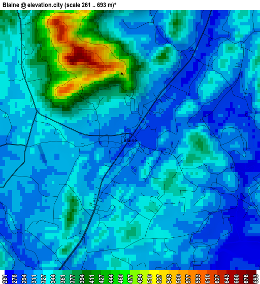
Below is the Elevation map of Blaine, which displays elevation range with different colors. Scale of the first map is from 261 to 693 m (856 to 2274 ft) with average elevation of 335.8 meters (=1102 ft) [note 1]
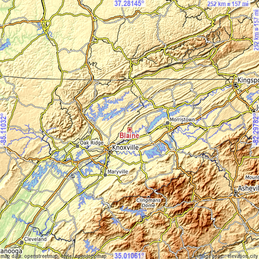
These maps also provides idea of topography and contour of this city, they are displayed at different zoom levels. More info about maps, scale and edge coordinates you can find below images.
| \ | Map #1 | Topo.Map |
| Scale [m] | 261..693 m | × |
| Scale [ft] | 856..2274 ft | × |
| Average | 335.8 m = 1102 ft | × |
| Width | 7.89 km = 4.9 mi | 252.5 km = 156.9 mi |
| Height | 7.89 km = 4.9 mi | 252.5 km = 156.9 mi |
| ↑Max Latitude | 36.189725° | 37.28145° |
| Latitude at center | 36.15425° | 36.15425° |
| ↓Min Latitude | 36.118759° | 35.01061° |
| ← Min Longitude | -83.748015° | -85.11032° |
| Longitude center | -83.70407° | -83.70407° |
| →Max Longitude | -83.660125° | -82.29782° |
Nearby cities:
Cities around Blaine sort by population:
• Knoxville elevation 277 m
29 km,  222°
222°
• Seymour 289 m
29.4 km,  183°
183°
• Jefferson City 371 m
19.3 km,  100°
100°
• Dandridge 305 m
30.2 km,  120°
120°
• Mascot 266 m
11 km,  199°
199°
• Maynardville 372 m
13.6 km,  321°
321°
• Plainview 343 m
8.6 km,  287°
287°
• Condon 346 m
8.6 km, 290°
• Norris 333 m
33 km,  278°
278°
• New Market 327 m
14.7 km,  112°
112°
• Rutledge 309 m
22.1 km,  50°
50°
• Luttrell 326 m
6.1 km,  326°
326°
Multilingual:
 En español:
Blaine elevación 289 m.
 En France:
Blaine élévation 289 m.


Sources and notes:
- [note 1] Map square and city borders are not equal. Map elevation data is calculated only from area inside that square.
- [src 1] Elevation data from geonames database provided with same terms of usage.
- [src 2] The elevation map of Blaine is generated using elevation data from NASA's 3 arcsec (90m) resolution SRTM data.
- [src 3] Base (background) map © OpenStreetMap contributors tiles are generated by Geofabrik and OpenTopoMap.
Copyright & License:
This Blaine Elevation Map is licensed under CC BY-SA. You may reuse any part from this page, if you give a proper credit by linking to this URL:
 More info on terms of use page.