Madisonville elevation
Madisonville (Tennessee, Monroe County), United States elevation is 304 meters and Madisonville elevation in feet is 997 ft above sea level [src 1]. Madisonville is a seat of a second-order administrative division (feature code) with elevation that is 25 meters (82 ft) bigger than average city elevation in United States.
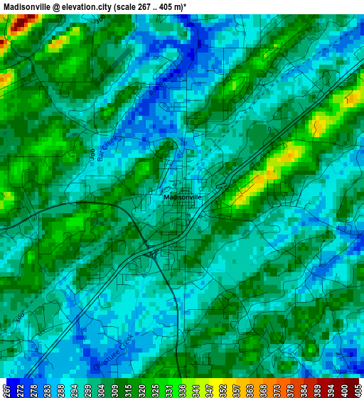
Below is the Elevation map of Madisonville, which displays elevation range with different colors. Scale of the first map is from 267 to 405 m (876 to 1329 ft) with average elevation of 302.7 meters (=993 ft) [note 1]
These maps also provides idea of topography and contour of this city, they are displayed at different zoom levels. More info about maps, scale and edge coordinates you can find below images.

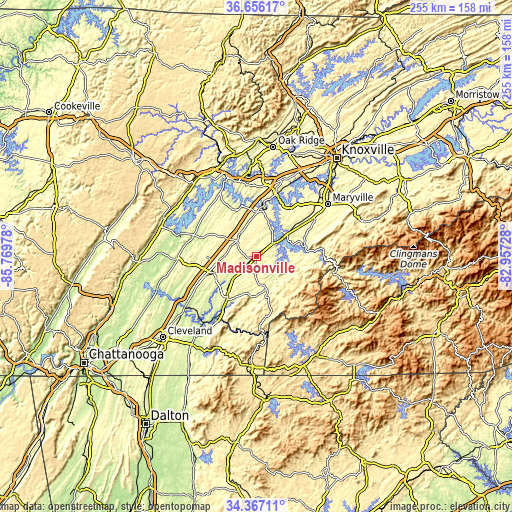
| \ | Map #1 | Map #2 | Topo.Map |
| Scale [m] | 267..405 m | 248..465 m | × |
| Scale [ft] | 876..1329 ft | 814..1526 ft | × |
| Average | 302.7 m = 993 ft | 306.7 m = 1006 ft | × |
| Width | 7.95 km = 4.9 mi | 15.91 km = 9.9 mi | 254.5 km = 158.1 mi |
| Height | 7.95 km = 4.9 mi | 15.91 km = 9.9 mi | 254.5 km = 158.1 mi |
| ↑Max Latitude | 35.55556° | 35.591304° | 36.65617° |
| Latitude at center | 35.5198° | 35.5198° | 35.5198° |
| ↓Min Latitude | 35.484024° | 35.448233° | 34.36711° |
| ← Min Longitude | -84.407475° | -84.451421° | -85.76978° |
| Longitude center | -84.36353° | -84.36353° | -84.36353° |
| →Max Longitude | -84.319585° | -84.275639° | -82.95728° |
Nearby cities:
Cities around Madisonville sort by population:
• Athens elevation 267 m
22.5 km,  247°
247°
• Lenoir City 252 m
32.3 km,  17°
17°
• Sweetwater 277 m
12.7 km,  315°
315°
• Kingston 236 m
42.2 km,  341°
341°
• Tellico Village 268 m
20.6 km,  28°
28°
• Loudon 252 m
23.8 km,  6°
6°
• Etowah 244 m
26.3 km,  213°
213°
• Decatur 238 m
38.6 km,  269°
269°
• Englewood 258 m
15.4 km,  226°
226°
• Vonore 261 m
13.5 km,  54°
54°
• Midtown 251 m
43.9 km, 335°
• Greenback 271 m
23.4 km, 47°
Multilingual:
 En español:
Madisonville elevación 304 m.
 En France:
Madisonville élévation 304 m.
 Auf Deutsch:
Madisonville höhe über dem Meeresspiegel ist 304 m.

Sources and notes:
- [note 1] Map square and city borders are not equal. Map elevation data is calculated only from area inside that square.
- [src 1] Elevation data from geonames database provided with same terms of usage.
- [src 2] The elevation map of Madisonville is generated using elevation data from NASA's 3 arcsec (90m) resolution SRTM data.
- [src 3] Base (background) map © OpenStreetMap contributors tiles are generated by Geofabrik and OpenTopoMap.
Copyright & License:
This Madisonville Elevation Map is licensed under CC BY-SA. You may reuse any part from this page, if you give a proper credit by linking to this URL:
 More info on terms of use page.