Englewood elevation
Englewood (Tennessee, McMinn County), United States elevation is 258 meters and Englewood elevation in feet is 846 ft above sea level [src 1]. Englewood is a populated place (feature code) with elevation that is 21 meters (69 ft) smaller than average city elevation in United States.
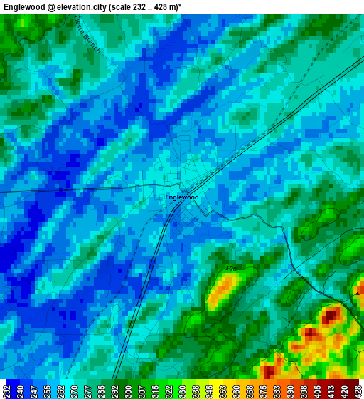
Below is the Elevation map of Englewood, which displays elevation range with different colors. Scale of the first map is from 232 to 428 m (761 to 1404 ft) with average elevation of 271.7 meters (=891 ft) [note 1]
These maps also provides idea of topography and contour of this city, they are displayed at different zoom levels. More info about maps, scale and edge coordinates you can find below images.
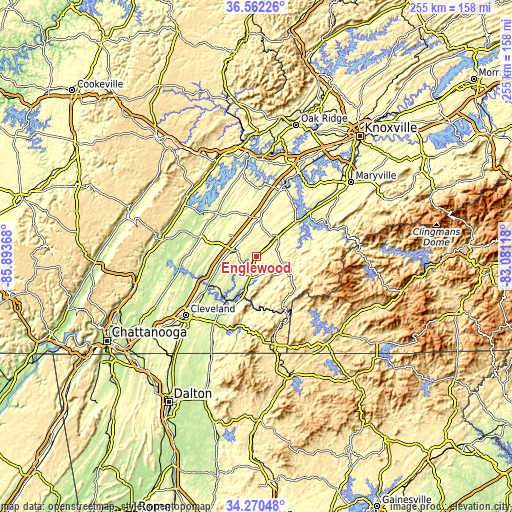
| \ | Map #1 | Topo.Map |
| Scale [m] | 232..428 m | × |
| Scale [ft] | 761..1404 ft | × |
| Average | 271.7 m = 891 ft | × |
| Width | 7.96 km = 4.9 mi | 254.8 km = 158.3 mi |
| Height | 7.96 km = 4.9 mi | 254.8 km = 158.3 mi |
| ↑Max Latitude | 35.460322° | 36.56226° |
| Latitude at center | 35.42452° | 35.42452° |
| ↓Min Latitude | 35.388702° | 34.27048° |
| ← Min Longitude | -84.531375° | -85.89368° |
| Longitude center | -84.48743° | -84.48743° |
| →Max Longitude | -84.443485° | -83.08118° |
Nearby cities:
Cities around Englewood sort by population:
• Athens elevation 267 m
9.8 km,  282°
282°
• Sweetwater 277 m
19.8 km,  6°
6°
• Tellico Village 268 m
35.6 km,  36°
36°
• Loudon 252 m
37 km,  22°
22°
• Madisonville 304 m
15.4 km,  46°
46°
• Etowah 244 m
11.7 km,  196°
196°
• Hopewell 222 m
42 km,  239°
239°
• East Cleveland 295 m
44.6 km,  228°
228°
• Decatur 238 m
29.2 km,  290°
290°
• Vonore 261 m
28.9 km, 50°
• Benton 225 m
31.6 km,  208°
208°
• Greenback 271 m
38.8 km, 47°
Multilingual:
 En español:
Englewood elevación 258 m.
 En France:
Englewood élévation 258 m.
 Auf Deutsch:
Englewood höhe über dem Meeresspiegel ist 258 m.

Sources and notes:
- [note 1] Map square and city borders are not equal. Map elevation data is calculated only from area inside that square.
- [src 1] Elevation data from geonames database provided with same terms of usage.
- [src 2] The elevation map of Englewood is generated using elevation data from NASA's 3 arcsec (90m) resolution SRTM data.
- [src 3] Base (background) map © OpenStreetMap contributors tiles are generated by Geofabrik and OpenTopoMap.
Copyright & License:
This Englewood Elevation Map is licensed under CC BY-SA. You may reuse any part from this page, if you give a proper credit by linking to this URL:
 More info on terms of use page.