Jonesborough elevation
Jonesborough (Tennessee, Washington County), United States elevation is 520 meters and Jonesborough elevation in feet is 1706 ft above sea level [src 1]. Jonesborough is a seat of a second-order administrative division (feature code) with elevation that is 241 meters (791 ft) bigger than average city elevation in United States.
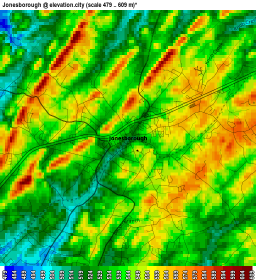
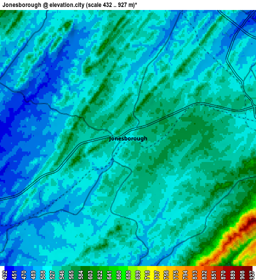
Below is the Elevation map of Jonesborough, which displays elevation range with different colors. Scale of the first map is from 479 to 609 m (1572 to 1998 ft) with average elevation of 540.9 meters (=1775 ft) [note 1]
These maps also provides idea of topography and contour of this city, they are displayed at different zoom levels. More info about maps, scale and edge coordinates you can find below images.
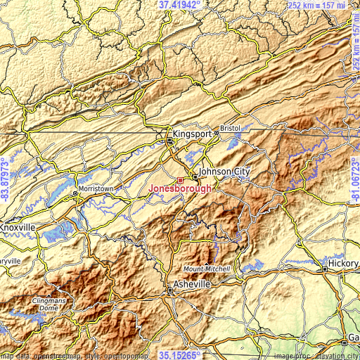
| \ | Map #1 | Map #2 | Topo.Map |
| Scale [m] | 479..609 m | 432..927 m | × |
| Scale [ft] | 1572..1998 ft | 1417..3041 ft | × |
| Average | 540.9 m = 1775 ft | 531 m = 1742 ft | × |
| Width | 7.88 km = 4.9 mi | 15.75 km = 9.8 mi | 252 km = 156.6 mi |
| Height | 7.88 km = 4.9 mi | 15.75 km = 9.8 mi | 252 km = 156.6 mi |
| ↑Max Latitude | 36.329681° | 36.365077° | 37.41942° |
| Latitude at center | 36.29427° | 36.29427° | 36.29427° |
| ↓Min Latitude | 36.258843° | 36.223399° | 35.15265° |
| ← Min Longitude | -82.517425° | -82.561371° | -83.87973° |
| Longitude center | -82.47348° | -82.47348° | -82.47348° |
| →Max Longitude | -82.429535° | -82.385589° | -81.06723° |
Nearby cities:
Cities around Jonesborough sort by population:
• Johnson City elevation 500 m
11 km,  78°
78°
• Colonial Heights 440 m
21.4 km,  352°
352°
• Erwin 514 m
17.3 km,  162°
162°
• Oak Grove 431 m
13.8 km,  18°
18°
• Spurgeon 443 m
16.2 km,  5°
5°
• Unicoi 591 m
15.6 km,  134°
134°
• Midway 576 m
4.5 km, 81°
• Pine Crest 517 m
14 km,  87°
87°
• Central 506 m
16.9 km, 77°
• Banner Hill 513 m
18.7 km,  166°
166°
• Fall Branch 457 m
19.3 km,  315°
315°
• Gray 483 m
14 km,  358°
358°
Multilingual:
 En español:
Jonesborough elevación 520 m.
 En France:
Jonesborough élévation 520 m.
 Auf Deutsch:
Jonesborough höhe über dem Meeresspiegel ist 520 m.

Sources and notes:
- [note 1] Map square and city borders are not equal. Map elevation data is calculated only from area inside that square.
- [src 1] Elevation data from geonames database provided with same terms of usage.
- [src 2] The elevation map of Jonesborough is generated using elevation data from NASA's 3 arcsec (90m) resolution SRTM data.
- [src 3] Base (background) map © OpenStreetMap contributors tiles are generated by Geofabrik and OpenTopoMap.
Copyright & License:
This Jonesborough Elevation Map is licensed under CC BY-SA. You may reuse any part from this page, if you give a proper credit by linking to this URL:
 More info on terms of use page.