Erwin elevation
Erwin (Tennessee, Unicoi County), United States elevation is 514 meters and Erwin elevation in feet is 1686 ft above sea level [src 1]. Erwin is a seat of a second-order administrative division (feature code) with elevation that is 235 meters (771 ft) bigger than average city elevation in United States.
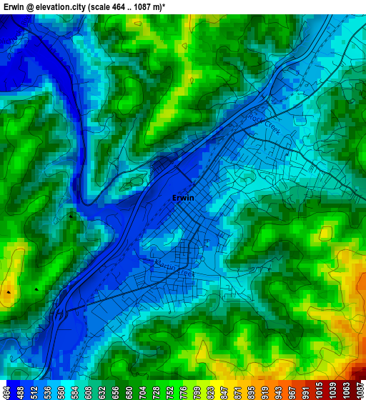
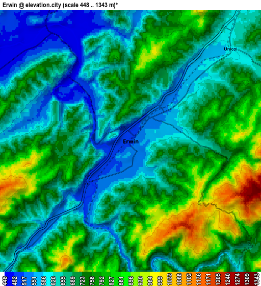
Below is the Elevation map of Erwin, which displays elevation range with different colors. Scale of the first map is from 464 to 1087 m (1522 to 3566 ft) with average elevation of 631.3 meters (=2071 ft) [note 1]
These maps also provides idea of topography and contour of this city, they are displayed at different zoom levels. More info about maps, scale and edge coordinates you can find below images.
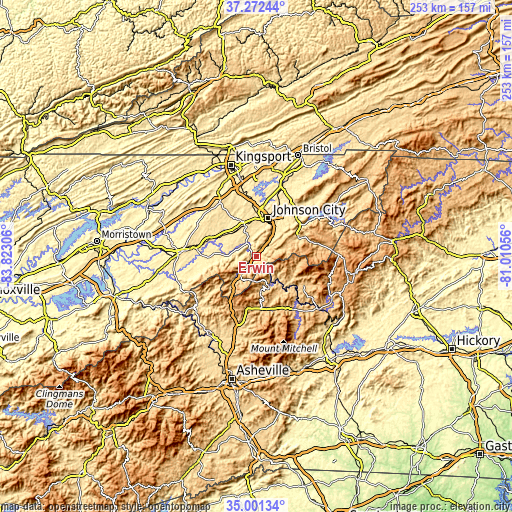
| \ | Map #1 | Map #2 | Topo.Map |
| Scale [m] | 464..1087 m | 448..1343 m | × |
| Scale [ft] | 1522..3566 ft | 1470..4406 ft | × |
| Average | 631.3 m = 2071 ft | 714.2 m = 2343 ft | × |
| Width | 7.89 km = 4.9 mi | 15.78 km = 9.8 mi | 252.5 km = 156.9 mi |
| Height | 7.89 km = 4.9 mi | 15.78 km = 9.8 mi | 252.5 km = 156.9 mi |
| ↑Max Latitude | 36.180589° | 36.216052° | 37.27244° |
| Latitude at center | 36.14511° | 36.14511° | 36.14511° |
| ↓Min Latitude | 36.109615° | 36.074104° | 35.00134° |
| ← Min Longitude | -82.460755° | -82.504701° | -83.82306° |
| Longitude center | -82.41681° | -82.41681° | -82.41681° |
| →Max Longitude | -82.372865° | -82.328919° | -81.01056° |
Nearby cities:
Cities around Erwin sort by population:
• Johnson City elevation 500 m
19.6 km,  16°
16°
• Elizabethton 467 m
29.2 km,  39°
39°
• Jonesborough 520 m
17.3 km,  342°
342°
• Oak Grove 431 m
29.7 km,  358°
358°
• Unicoi 591 m
8.2 km,  47°
47°
• Tusculum 455 m
30.9 km,  276°
276°
• Midway 576 m
17.2 km, 357°
• Pine Crest 517 m
19.3 km,  27°
27°
• Central 506 m
23.1 km, 29°
• Burnsville 864 m
27.4 km,  157°
157°
• Banner Hill 513 m
1.8 km,  203°
203°
• Bakersville 760 m
27.3 km,  121°
121°
Multilingual:
 En español:
Erwin elevación 514 m.
 En France:
Erwin élévation 514 m.


Sources and notes:
- [note 1] Map square and city borders are not equal. Map elevation data is calculated only from area inside that square.
- [src 1] Elevation data from geonames database provided with same terms of usage.
- [src 2] The elevation map of Erwin is generated using elevation data from NASA's 3 arcsec (90m) resolution SRTM data.
- [src 3] Base (background) map © OpenStreetMap contributors tiles are generated by Geofabrik and OpenTopoMap.
Copyright & License:
This Erwin Elevation Map is licensed under CC BY-SA. You may reuse any part from this page, if you give a proper credit by linking to this URL:
 More info on terms of use page.