Colonial Heights elevation
Colonial Heights (Tennessee, Sullivan County), United States elevation is 440 meters and Colonial Heights elevation in feet is 1444 ft above sea level [src 1]. Colonial Heights is a populated place (feature code) with elevation that is 161 meters (528 ft) bigger than average city elevation in United States.
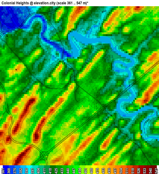
Below is the Elevation map of Colonial Heights, which displays elevation range with different colors. Scale of the first map is from 361 to 547 m (1184 to 1795 ft) with average elevation of 437.7 meters (=1436 ft) [note 1]
These maps also provides idea of topography and contour of this city, they are displayed at different zoom levels. More info about maps, scale and edge coordinates you can find below images.
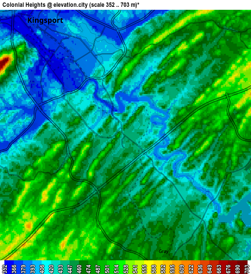
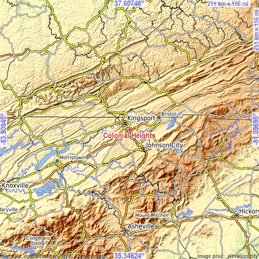
| \ | Map #1 | Map #2 | Topo.Map |
| Scale [m] | 361..547 m | 352..703 m | × |
| Scale [ft] | 1184..1795 ft | 1155..2306 ft | × |
| Average | 437.7 m = 1436 ft | 450.6 m = 1478 ft | × |
| Width | 7.86 km = 4.9 mi | 15.71 km = 9.8 mi | 251.4 km = 156.2 mi |
| Height | 7.86 km = 4.9 mi | 15.71 km = 9.8 mi | 251.4 km = 156.2 mi |
| ↑Max Latitude | 36.520424° | 36.555733° | 37.60746° |
| Latitude at center | 36.4851° | 36.4851° | 36.4851° |
| ↓Min Latitude | 36.449759° | 36.414403° | 35.34624° |
| ← Min Longitude | -82.547145° | -82.591091° | -83.90945° |
| Longitude center | -82.5032° | -82.5032° | -82.5032° |
| →Max Longitude | -82.459255° | -82.415309° | -81.09695° |
Nearby cities:
Cities around Colonial Heights sort by population:
• Kingsport elevation 369 m
8.8 km,  323°
323°
• Bloomingdale 434 m
11.1 km,  6°
6°
• Church Hill 375 m
19.2 km,  282°
282°
• Mount Carmel 414 m
15.6 km,  295°
295°
• Jonesborough 520 m
21.4 km,  172°
172°
• Oak Grove 431 m
10.8 km,  139°
139°
• Spurgeon 443 m
6.6 km, 140°
• Blountville 469 m
16.6 km,  71°
71°
• Gate City 404 m
18.4 km,  337°
337°
• Fall Branch 457 m
13.1 km,  235°
235°
• Weber City 400 m
16.2 km, 341°
• Gray 483 m
7.6 km,  161°
161°
Multilingual:
 En español:
Colonial Heights elevación 440 m.
 En France:
Colonial Heights élévation 440 m.
 Auf Deutsch:
Colonial Heights höhe über dem Meeresspiegel ist 440 m.

Sources and notes:
- [note 1] Map square and city borders are not equal. Map elevation data is calculated only from area inside that square.
- [src 1] Elevation data from geonames database provided with same terms of usage.
- [src 2] The elevation map of Colonial Heights is generated using elevation data from NASA's 3 arcsec (90m) resolution SRTM data.
- [src 3] Base (background) map © OpenStreetMap contributors tiles are generated by Geofabrik and OpenTopoMap.
Copyright & License:
This Colonial Heights Elevation Map is licensed under CC BY-SA. You may reuse any part from this page, if you give a proper credit by linking to this URL:
 More info on terms of use page.