Halls elevation
Halls (Tennessee, Lauderdale County), United States elevation is 94 meters and Halls elevation in feet is 308 ft above sea level [src 1]. Halls is a populated place (feature code) with elevation that is 185 meters (607 ft) smaller than average city elevation in United States.
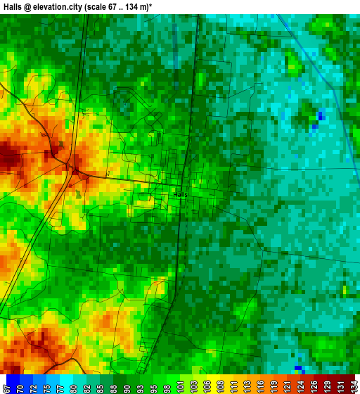
Below is the Elevation map of Halls, which displays elevation range with different colors. Scale of the first map is from 67 to 134 m (220 to 440 ft) with average elevation of 92.9 meters (=305 ft) [note 1]
These maps also provides idea of topography and contour of this city, they are displayed at different zoom levels. More info about maps, scale and edge coordinates you can find below images.
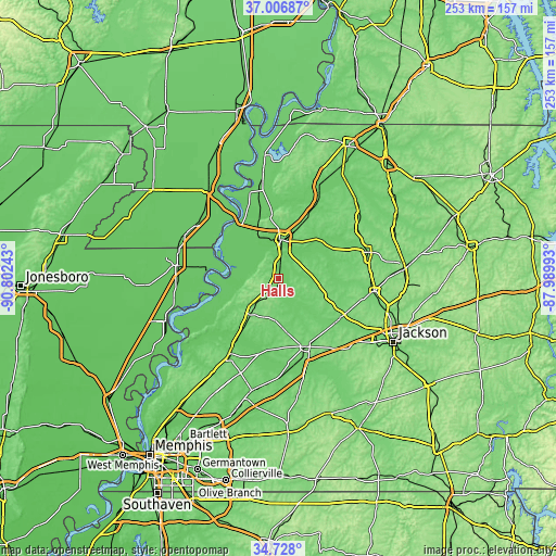
| \ | Map #1 | Topo.Map |
| Scale [m] | 67..134 m | × |
| Scale [ft] | 220..440 ft | × |
| Average | 92.9 m = 305 ft | × |
| Width | 7.92 km = 4.9 mi | 253.4 km = 157.5 mi |
| Height | 7.92 km = 4.9 mi | 253.4 km = 157.5 mi |
| ↑Max Latitude | 35.91123° | 37.00687° |
| Latitude at center | 35.87563° | 35.87563° |
| ↓Min Latitude | 35.840014° | 34.728° |
| ← Min Longitude | -89.440125° | -90.80243° |
| Longitude center | -89.39618° | -89.39618° |
| →Max Longitude | -89.352235° | -87.98993° |
Nearby cities:
Cities around Halls sort by population:
• Dyersburg elevation 96 m
17.7 km,  3°
3°
• Brownsville 117 m
33.6 km,  158°
158°
• Covington 105 m
41.3 km,  213°
213°
• Humboldt 111 m
43.7 km,  98°
98°
• Ripley 140 m
18.8 km,  219°
219°
• Caruthersville 85 m
42.3 km,  326°
326°
• Trenton 106 m
42.6 km,  74°
74°
• Newbern 116 m
29 km,  24°
24°
• Central 151 m
15 km,  237°
237°
• Alamo 110 m
27.1 km,  111°
111°
• Bells 100 m
33.3 km,  123°
123°
• Dyer 115 m
42 km,  59°
59°
Multilingual:
 En español:
Halls elevación 94 m.
 En France:
Halls élévation 94 m.


Sources and notes:
- [note 1] Map square and city borders are not equal. Map elevation data is calculated only from area inside that square.
- [src 1] Elevation data from geonames database provided with same terms of usage.
- [src 2] The elevation map of Halls is generated using elevation data from NASA's 3 arcsec (90m) resolution SRTM data.
- [src 3] Base (background) map © OpenStreetMap contributors tiles are generated by Geofabrik and OpenTopoMap.
Copyright & License:
This Halls Elevation Map is licensed under CC BY-SA. You may reuse any part from this page, if you give a proper credit by linking to this URL:
 More info on terms of use page.