Trenton elevation
Trenton (Tennessee, Gibson County), United States elevation is 106 meters and Trenton elevation in feet is 348 ft above sea level [src 1]. Trenton is a seat of a second-order administrative division (feature code) with elevation that is 173 meters (568 ft) smaller than average city elevation in United States.
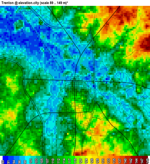
Below is the Elevation map of Trenton, which displays elevation range with different colors. Scale of the first map is from 89 to 149 m (292 to 489 ft) with average elevation of 109.1 meters (=358 ft) [note 1]
These maps also provides idea of topography and contour of this city, they are displayed at different zoom levels. More info about maps, scale and edge coordinates you can find below images.
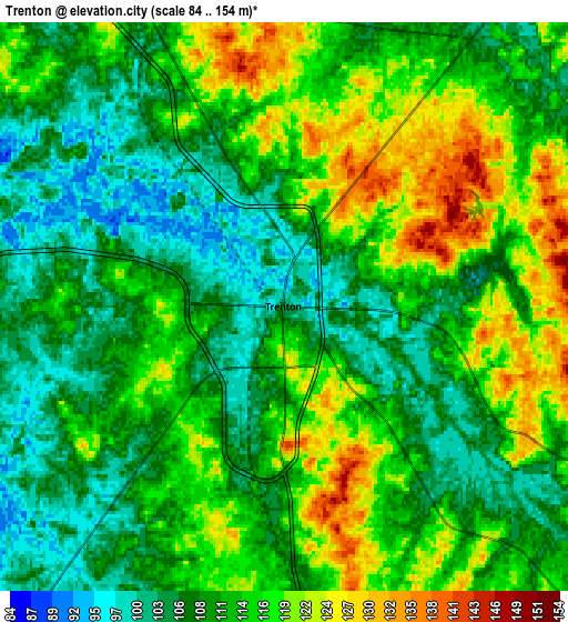
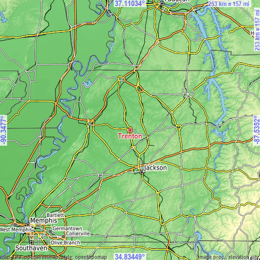
| \ | Map #1 | Map #2 | Topo.Map |
| Scale [m] | 89..149 m | 84..154 m | × |
| Scale [ft] | 292..489 ft | 276..505 ft | × |
| Average | 109.1 m = 358 ft | 112.2 m = 368 ft | × |
| Width | 7.91 km = 4.9 mi | 15.82 km = 9.8 mi | 253.1 km = 157.3 mi |
| Height | 7.91 km = 4.9 mi | 15.82 km = 9.8 mi | 253 km = 157.2 mi |
| ↑Max Latitude | 36.016173° | 36.05171° | 37.11034° |
| Latitude at center | 35.98062° | 35.98062° | 35.98062° |
| ↓Min Latitude | 35.945051° | 35.909465° | 34.83449° |
| ← Min Longitude | -88.985395° | -89.029341° | -90.3477° |
| Longitude center | -88.94145° | -88.94145° | -88.94145° |
| →Max Longitude | -88.897505° | -88.853559° | -87.5352° |
Nearby cities:
Cities around Trenton sort by population:
• Humboldt elevation 111 m
18 km,  172°
172°
• Milan 128 m
17.8 km,  112°
112°
• Medina 149 m
24.8 km,  142°
142°
• Newbern 116 m
32.3 km,  297°
297°
• Alamo 110 m
26.9 km,  216°
216°
• Bells 100 m
32.7 km,  203°
203°
• Dyer 115 m
10.7 km,  333°
333°
• Greenfield 136 m
23 km,  33°
33°
• Three Way 130 m
23.9 km,  162°
162°
• Kenton 98 m
25.5 km,  345°
345°
• Rutherford 100 m
16.8 km, 346°
• Bradford 112 m
15.9 km,  47°
47°
Multilingual:
 En español:
Trenton elevación 106 m.
 En France:
Trenton élévation 106 m.


Sources and notes:
- [note 1] Map square and city borders are not equal. Map elevation data is calculated only from area inside that square.
- [src 1] Elevation data from geonames database provided with same terms of usage.
- [src 2] The elevation map of Trenton is generated using elevation data from NASA's 3 arcsec (90m) resolution SRTM data.
- [src 3] Base (background) map © OpenStreetMap contributors tiles are generated by Geofabrik and OpenTopoMap.
Copyright & License:
This Trenton Elevation Map is licensed under CC BY-SA. You may reuse any part from this page, if you give a proper credit by linking to this URL:
 More info on terms of use page.