Kenton elevation
Kenton (Tennessee, Obion County), United States elevation is 98 meters and Kenton elevation in feet is 322 ft above sea level [src 1]. Kenton is a populated place (feature code) with elevation that is 181 meters (594 ft) smaller than average city elevation in United States.
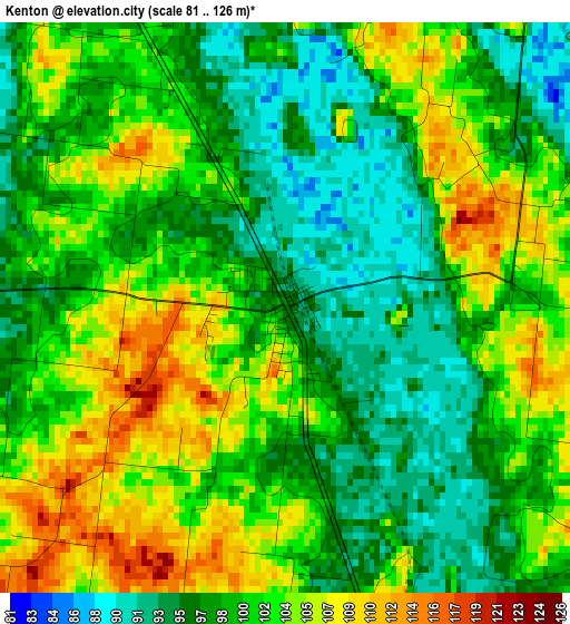
Below is the Elevation map of Kenton, which displays elevation range with different colors. Scale of the first map is from 81 to 126 m (266 to 413 ft) with average elevation of 100.5 meters (=330 ft) [note 1]
These maps also provides idea of topography and contour of this city, they are displayed at different zoom levels. More info about maps, scale and edge coordinates you can find below images.
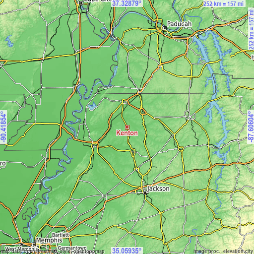
| \ | Map #1 | Topo.Map |
| Scale [m] | 81..126 m | × |
| Scale [ft] | 266..413 ft | × |
| Average | 100.5 m = 330 ft | × |
| Width | 7.89 km = 4.9 mi | 252.3 km = 156.8 mi |
| Height | 7.89 km = 4.9 mi | 252.3 km = 156.8 mi |
| ↑Max Latitude | 36.237743° | 37.32879° |
| Latitude at center | 36.20229° | 36.20229° |
| ↓Min Latitude | 36.166821° | 35.05935° |
| ← Min Longitude | -89.056235° | -90.41854° |
| Longitude center | -89.01229° | -89.01229° |
| →Max Longitude | -88.968345° | -87.60604° |
Nearby cities:
Cities around Kenton sort by population:
• Martin elevation 127 m
21.4 km,  42°
42°
• Union City 105 m
25 km,  350°
350°
• Trenton 106 m
25.5 km,  165°
165°
• Newbern 116 m
24.5 km,  246°
246°
• Dresden 132 m
29 km,  70°
70°
• Dyer 115 m
15.2 km, 173°
• Greenfield 136 m
19.8 km,  105°
105°
• Englewood 135 m
22.3 km,  325°
325°
• Troy 115 m
20.4 km,  318°
318°
• Rutherford 100 m
8.6 km,  164°
164°
• Obion 87 m
17.3 km,  291°
291°
• Bradford 112 m
22.9 km,  127°
127°
Multilingual:
 En español:
Kenton elevación 98 m.
 En France:
Kenton élévation 98 m.


Sources and notes:
- [note 1] Map square and city borders are not equal. Map elevation data is calculated only from area inside that square.
- [src 1] Elevation data from geonames database provided with same terms of usage.
- [src 2] The elevation map of Kenton is generated using elevation data from NASA's 3 arcsec (90m) resolution SRTM data.
- [src 3] Base (background) map © OpenStreetMap contributors tiles are generated by Geofabrik and OpenTopoMap.
Copyright & License:
This Kenton Elevation Map is licensed under CC BY-SA. You may reuse any part from this page, if you give a proper credit by linking to this URL:
 More info on terms of use page.