Grimsley elevation
Grimsley (Tennessee, Fentress County), United States elevation is 531 meters and Grimsley elevation in feet is 1742 ft above sea level [src 1]. Grimsley is a populated place (feature code) with elevation that is 252 meters (827 ft) bigger than average city elevation in United States.
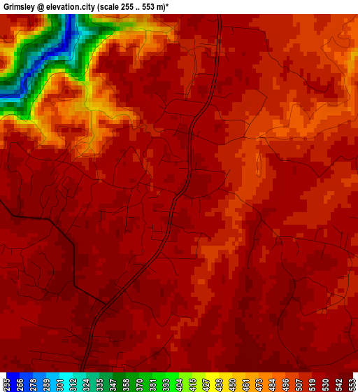
Below is the Elevation map of Grimsley, which displays elevation range with different colors. Scale of the first map is from 255 to 553 m (837 to 1814 ft) with average elevation of 512.8 meters (=1682 ft) [note 1]
These maps also provides idea of topography and contour of this city, they are displayed at different zoom levels. More info about maps, scale and edge coordinates you can find below images.
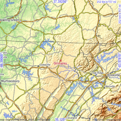
| \ | Map #1 | Topo.Map |
| Scale [m] | 255..553 m | × |
| Scale [ft] | 837..1814 ft | × |
| Average | 512.8 m = 1682 ft | × |
| Width | 7.88 km = 4.9 mi | 252.1 km = 156.6 mi |
| Height | 7.88 km = 4.9 mi | 252.1 km = 156.6 mi |
| ↑Max Latitude | 36.302434° | 37.39256° |
| Latitude at center | 36.26701° | 36.26701° |
| ↓Min Latitude | 36.23157° | 35.125° |
| ← Min Longitude | -85.028345° | -86.39065° |
| Longitude center | -84.9844° | -84.9844° |
| →Max Longitude | -84.940455° | -83.57815° |
Nearby cities:
Cities around Grimsley sort by population:
• Cookeville elevation 338 m
47.8 km,  255°
255°
• Crossville 565 m
35.6 km,  186°
186°
• Fairfield Glade 636 m
30.9 km,  163°
163°
• Livingston 314 m
33 km,  293°
293°
• Lake Tansi 587 m
44.3 km, 188°
• Algood 338 m
42.4 km, 259°
• Monterey 574 m
28.7 km,  242°
242°
• Albany 292 m
49 km,  344°
344°
• Jamestown 524 m
18.5 km,  14°
14°
• Huntsville 404 m
47 km,  70°
70°
• Wartburg 422 m
39.2 km,  117°
117°
• Byrdstown 316 m
36.6 km, 339°
Multilingual:
 En español:
Grimsley elevación 531 m.
 En France:
Grimsley élévation 531 m.
 Auf Deutsch:
Grimsley höhe über dem Meeresspiegel ist 531 m.

Sources and notes:
- [note 1] Map square and city borders are not equal. Map elevation data is calculated only from area inside that square.
- [src 1] Elevation data from geonames database provided with same terms of usage.
- [src 2] The elevation map of Grimsley is generated using elevation data from NASA's 3 arcsec (90m) resolution SRTM data.
- [src 3] Base (background) map © OpenStreetMap contributors tiles are generated by Geofabrik and OpenTopoMap.
Copyright & License:
This Grimsley Elevation Map is licensed under CC BY-SA. You may reuse any part from this page, if you give a proper credit by linking to this URL:
 More info on terms of use page.