Wartburg elevation
Wartburg (Tennessee, Morgan County), United States elevation is 422 meters and Wartburg elevation in feet is 1385 ft above sea level [src 1]. Wartburg is a seat of a second-order administrative division (feature code) with elevation that is 143 meters (469 ft) bigger than average city elevation in United States.
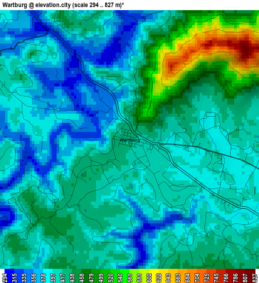
Below is the Elevation map of Wartburg, which displays elevation range with different colors. Scale of the first map is from 294 to 827 m (965 to 2713 ft) with average elevation of 417 meters (=1368 ft) [note 1]
These maps also provides idea of topography and contour of this city, they are displayed at different zoom levels. More info about maps, scale and edge coordinates you can find below images.
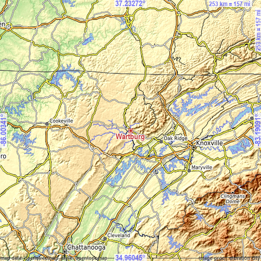
| \ | Map #1 | Topo.Map |
| Scale [m] | 294..827 m | × |
| Scale [ft] | 965..2713 ft | × |
| Average | 417 m = 1368 ft | × |
| Width | 7.9 km = 4.9 mi | 252.7 km = 157 mi |
| Height | 7.9 km = 4.9 mi | 252.7 km = 157 mi |
| ↑Max Latitude | 36.140297° | 37.23272° |
| Latitude at center | 36.1048° | 36.1048° |
| ↓Min Latitude | 36.069287° | 34.96045° |
| ← Min Longitude | -84.641105° | -86.00341° |
| Longitude center | -84.59716° | -84.59716° |
| →Max Longitude | -84.553215° | -83.19091° |
Nearby cities:
Cities around Wartburg sort by population:
• Oak Ridge elevation 259 m
31.3 km,  109°
109°
• Fairfield Glade 636 m
28.5 km,  245°
245°
• Harriman 245 m
19.4 km,  168°
168°
• Kingston 236 m
26.1 km,  162°
162°
• Rockwood 272 m
27.7 km,  196°
196°
• Oliver Springs 246 m
23.7 km, 106°
• Coalfield 313 m
18 km,  118°
118°
• Caryville 335 m
39.9 km,  57°
57°
• Rocky Top 266 m
41.7 km,  72°
72°
• Midtown 251 m
25.2 km, 173°
• Huntsville 404 m
35.2 km,  15°
15°
• Grimsley 531 m
39.2 km,  297°
297°
Multilingual:
 En español:
Wartburg elevación 422 m.
 En France:
Wartburg élévation 422 m.
 Auf Deutsch:
Wartburg höhe über dem Meeresspiegel ist 422 m.

Sources and notes:
- [note 1] Map square and city borders are not equal. Map elevation data is calculated only from area inside that square.
- [src 1] Elevation data from geonames database provided with same terms of usage.
- [src 2] The elevation map of Wartburg is generated using elevation data from NASA's 3 arcsec (90m) resolution SRTM data.
- [src 3] Base (background) map © OpenStreetMap contributors tiles are generated by Geofabrik and OpenTopoMap.
Copyright & License:
This Wartburg Elevation Map is licensed under CC BY-SA. You may reuse any part from this page, if you give a proper credit by linking to this URL:
 More info on terms of use page.