Erin elevation
Erin (Tennessee, Houston County), United States elevation is 136 meters and Erin elevation in feet is 446 ft above sea level [src 1]. Erin is a seat of a second-order administrative division (feature code) with elevation that is 143 meters (469 ft) smaller than average city elevation in United States.
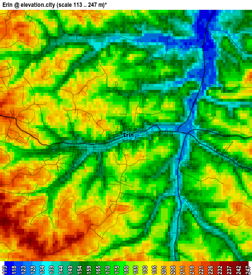
Below is the Elevation map of Erin, which displays elevation range with different colors. Scale of the first map is from 113 to 247 m (371 to 810 ft) with average elevation of 176.2 meters (=578 ft) [note 1]
These maps also provides idea of topography and contour of this city, they are displayed at different zoom levels. More info about maps, scale and edge coordinates you can find below images.
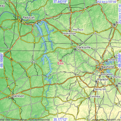
| \ | Map #1 | Topo.Map |
| Scale [m] | 113..247 m | × |
| Scale [ft] | 371..810 ft | × |
| Average | 176.2 m = 578 ft | × |
| Width | 7.87 km = 4.9 mi | 252 km = 156.6 mi |
| Height | 7.87 km = 4.9 mi | 252 km = 156.6 mi |
| ↑Max Latitude | 36.35379° | 37.44319° |
| Latitude at center | 36.31839° | 36.31839° |
| ↓Min Latitude | 36.282974° | 35.17712° |
| ← Min Longitude | -87.738685° | -89.10099° |
| Longitude center | -87.69474° | -87.69474° |
| →Max Longitude | -87.650795° | -86.28849° |
Nearby cities:
Cities around Erin sort by population:
• Clarksville elevation 145 m
38.1 km,  51°
51°
• Dickson 248 m
38.5 km,  134°
134°
• Fort Campbell North 166 m
42.8 km,  29°
29°
• Oak Grove 166 m
44.6 km, 30°
• Waverly 161 m
27.6 km,  198°
198°
• New Johnsonville 131 m
41.1 km,  216°
216°
• Johnsonville 112 m
36.9 km, 218°
• McEwen 251 m
24.1 km,  166°
166°
• Charlotte 204 m
35.5 km,  116°
116°
• Burns 246 m
45.2 km, 130°
• Dover 128 m
22.8 km,  325°
325°
• Tennessee Ridge 229 m
7.1 km,  264°
264°
Multilingual:
 En español:
Erin elevación 136 m.
 En France:
Erin élévation 136 m.


Sources and notes:
- [note 1] Map square and city borders are not equal. Map elevation data is calculated only from area inside that square.
- [src 1] Elevation data from geonames database provided with same terms of usage.
- [src 2] The elevation map of Erin is generated using elevation data from NASA's 3 arcsec (90m) resolution SRTM data.
- [src 3] Base (background) map © OpenStreetMap contributors tiles are generated by Geofabrik and OpenTopoMap.
Copyright & License:
This Erin Elevation Map is licensed under CC BY-SA. You may reuse any part from this page, if you give a proper credit by linking to this URL:
 More info on terms of use page.