Dickson elevation
Dickson (Tennessee, Dickson County), United States elevation is 248 meters and Dickson elevation in feet is 814 ft above sea level [src 1]. Dickson is a populated place (feature code) with elevation that is 31 meters (102 ft) smaller than average city elevation in United States.
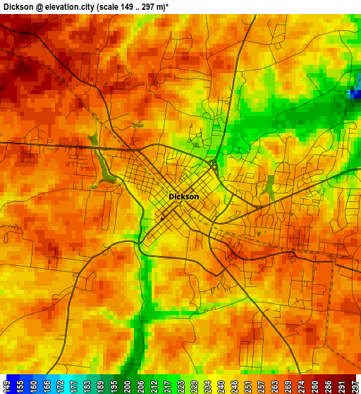
Below is the Elevation map of Dickson, which displays elevation range with different colors. Scale of the first map is from 149 to 297 m (489 to 974 ft) with average elevation of 251.1 meters (=824 ft) [note 1]
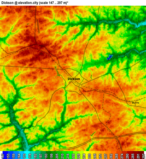
These maps also provides idea of topography and contour of this city, they are displayed at different zoom levels. More info about maps, scale and edge coordinates you can find below images.
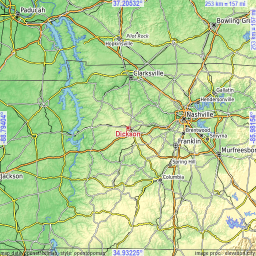
| \ | Map #1 | Map #2 | Topo.Map |
| Scale [m] | 149..297 m | 147..297 m | × |
| Scale [ft] | 489..974 ft | 482..974 ft | × |
| Average | 251.1 m = 824 ft | 241.8 m = 793 ft | × |
| Width | 7.9 km = 4.9 mi | 15.8 km = 9.8 mi | 252.7 km = 157 mi |
| Height | 7.9 km = 4.9 mi | 15.8 km = 9.8 mi | 252.7 km = 157 mi |
| ↑Max Latitude | 36.11251° | 36.148003° | 37.20532° |
| Latitude at center | 36.077° | 36.077° | 36.077° |
| ↓Min Latitude | 36.041474° | 36.005932° | 34.93225° |
| ← Min Longitude | -87.431735° | -87.475681° | -88.79404° |
| Longitude center | -87.38779° | -87.38779° | -87.38779° |
| →Max Longitude | -87.343845° | -87.299899° | -85.98154° |
Nearby cities:
Cities around Dickson sort by population:
• Fairview elevation 251 m
26.2 km,  113°
113°
• Ashland City 132 m
36.4 km,  52°
52°
• Waverly 161 m
36.6 km,  271°
271°
• Centerville 192 m
33.9 km,  192°
192°
• White Bluff 253 m
15.4 km,  77°
77°
• Kingston Springs 159 m
24.7 km, 83°
• Pegram 170 m
30.4 km,  85°
85°
• McEwen 251 m
22.3 km,  278°
278°
• Charlotte 204 m
12 km,  21°
21°
• Burns 246 m
7.3 km, 111°
• Erin 136 m
38.5 km,  314°
314°
• Bon Aqua Junction 278 m
18 km,  157°
157°
Multilingual:
 En español:
Dickson elevación 248 m.
 En France:
Dickson élévation 248 m.


Sources and notes:
- [note 1] Map square and city borders are not equal. Map elevation data is calculated only from area inside that square.
- [src 1] Elevation data from geonames database provided with same terms of usage.
- [src 2] The elevation map of Dickson is generated using elevation data from NASA's 3 arcsec (90m) resolution SRTM data.
- [src 3] Base (background) map © OpenStreetMap contributors tiles are generated by Geofabrik and OpenTopoMap.
Copyright & License:
This Dickson Elevation Map is licensed under CC BY-SA. You may reuse any part from this page, if you give a proper credit by linking to this URL:
 More info on terms of use page.