Kingston Springs elevation
Kingston Springs (Tennessee, Cheatham County), United States elevation is 159 meters and Kingston Springs elevation in feet is 522 ft above sea level [src 1]. Kingston Springs is a populated place (feature code) with elevation that is 120 meters (394 ft) smaller than average city elevation in United States.
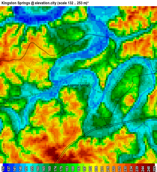
Below is the Elevation map of Kingston Springs, which displays elevation range with different colors. Scale of the first map is from 132 to 253 m (433 to 830 ft) with average elevation of 184.5 meters (=605 ft) [note 1]
These maps also provides idea of topography and contour of this city, they are displayed at different zoom levels. More info about maps, scale and edge coordinates you can find below images.
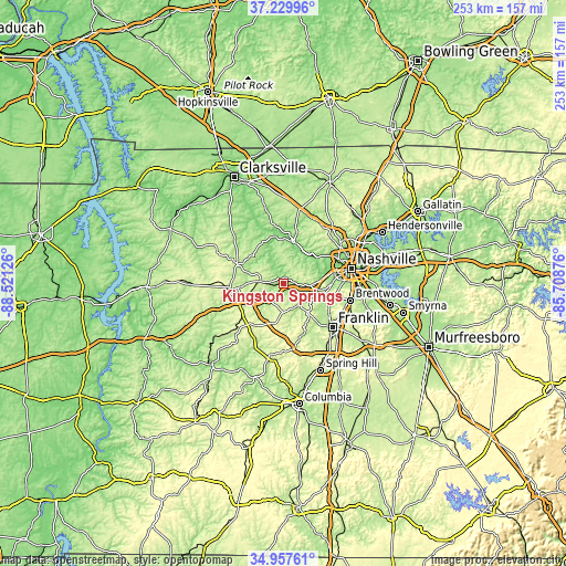
| \ | Map #1 | Topo.Map |
| Scale [m] | 132..253 m | × |
| Scale [ft] | 433..830 ft | × |
| Average | 184.5 m = 605 ft | × |
| Width | 7.9 km = 4.9 mi | 252.7 km = 157 mi |
| Height | 7.9 km = 4.9 mi | 252.7 km = 157 mi |
| ↑Max Latitude | 36.137498° | 37.22996° |
| Latitude at center | 36.102° | 36.102° |
| ↓Min Latitude | 36.066486° | 34.95761° |
| ← Min Longitude | -87.158955° | -88.52126° |
| Longitude center | -87.11501° | -87.11501° |
| →Max Longitude | -87.071065° | -85.70876° |
Nearby cities:
Cities around Kingston Springs sort by population:
• Franklin elevation 201 m
29.6 km,  131°
131°
• Dickson 248 m
24.7 km,  263°
263°
• Fairview 251 m
13.4 km,  182°
182°
• Forest Hills 203 m
24.6 km,  98°
98°
• Oak Hill 185 m
29.9 km,  93°
93°
• Ashland City 132 m
19.7 km,  13°
13°
• White Bluff 253 m
9.5 km,  273°
273°
• Belle Meade 174 m
23.2 km, 91°
• Pegram 170 m
5.7 km, 91°
• Charlotte 204 m
21.8 km,  292°
292°
• Burns 246 m
18.6 km,  253°
253°
• Bon Aqua Junction 278 m
26.2 km,  222°
222°
Multilingual:
 En español:
Kingston Springs elevación 159 m.
 En France:
Kingston Springs élévation 159 m.
 Auf Deutsch:
Kingston Springs höhe über dem Meeresspiegel ist 159 m.

Sources and notes:
- [note 1] Map square and city borders are not equal. Map elevation data is calculated only from area inside that square.
- [src 1] Elevation data from geonames database provided with same terms of usage.
- [src 2] The elevation map of Kingston Springs is generated using elevation data from NASA's 3 arcsec (90m) resolution SRTM data.
- [src 3] Base (background) map © OpenStreetMap contributors tiles are generated by Geofabrik and OpenTopoMap.
Copyright & License:
This Kingston Springs Elevation Map is licensed under CC BY-SA. You may reuse any part from this page, if you give a proper credit by linking to this URL:
 More info on terms of use page.