Williston elevation
Williston (South Carolina, Barnwell County), United States elevation is 109 meters and Williston elevation in feet is 358 ft above sea level [src 1]. Williston is a populated place (feature code) with elevation that is 170 meters (558 ft) smaller than average city elevation in United States.
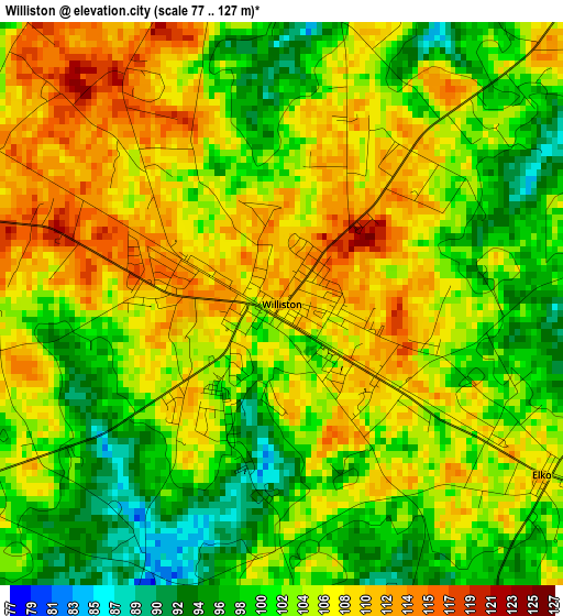
Below is the Elevation map of Williston, which displays elevation range with different colors. Scale of the first map is from 77 to 127 m (253 to 417 ft) with average elevation of 103.9 meters (=341 ft) [note 1]
These maps also provides idea of topography and contour of this city, they are displayed at different zoom levels. More info about maps, scale and edge coordinates you can find below images.
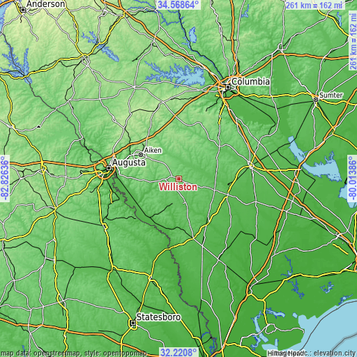
| \ | Map #1 | Topo.Map |
| Scale [m] | 77..127 m | × |
| Scale [ft] | 253..417 ft | × |
| Average | 103.9 m = 341 ft | × |
| Width | 8.16 km = 5.1 mi | 261.1 km = 162.2 mi |
| Height | 8.16 km = 5.1 mi | 261.1 km = 162.2 mi |
| ↑Max Latitude | 33.439329° | 34.56864° |
| Latitude at center | 33.40265° | 33.40265° |
| ↓Min Latitude | 33.365956° | 32.2208° |
| ← Min Longitude | -81.464055° | -82.82636° |
| Longitude center | -81.42011° | -81.42011° |
| →Max Longitude | -81.376165° | -80.01386° |
Nearby cities:
Cities around Williston sort by population:
• Aiken elevation 161 m
32.8 km,  302°
302°
• Boiling Springs 69 m
29.8 km,  181°
181°
• Barnwell 69 m
18.4 km,  161°
161°
• Bamberg 52 m
37.7 km,  108°
108°
• Denmark 76 m
27.3 km, 109°
• Gloverville 64 m
40.4 km,  289°
289°
• Graniteville 75 m
40.2 km, 296°
• Blackville 93 m
14.7 km, 109°
• New Ellenton 127 m
24.7 km,  274°
274°
• Jackson 65 m
35.2 km,  255°
255°
• Langley 63 m
41.4 km, 288°
• Warrenville 78 m
39.2 km, 294°
Multilingual:
 En español:
Williston elevación 109 m.
 En France:
Williston élévation 109 m.
 Auf Deutsch:
Williston höhe über dem Meeresspiegel ist 109 m.

Sources and notes:
- [note 1] Map square and city borders are not equal. Map elevation data is calculated only from area inside that square.
- [src 1] Elevation data from geonames database provided with same terms of usage.
- [src 2] The elevation map of Williston is generated using elevation data from NASA's 3 arcsec (90m) resolution SRTM data.
- [src 3] Base (background) map © OpenStreetMap contributors tiles are generated by Geofabrik and OpenTopoMap.
Copyright & License:
This Williston Elevation Map is licensed under CC BY-SA. You may reuse any part from this page, if you give a proper credit by linking to this URL:
 More info on terms of use page.