Lancaster elevation
Lancaster (South Carolina, Lancaster County), United States elevation is 165 meters and Lancaster elevation in feet is 541 ft above sea level [src 1]. Lancaster is a seat of a second-order administrative division (feature code) with elevation that is 114 meters (374 ft) smaller than average city elevation in United States.
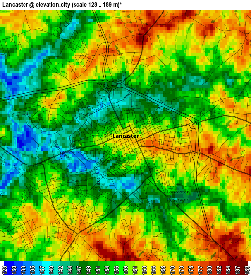
Below is the Elevation map of Lancaster, which displays elevation range with different colors. Scale of the first map is from 128 to 189 m (420 to 620 ft) with average elevation of 158.4 meters (=520 ft) [note 1]
These maps also provides idea of topography and contour of this city, they are displayed at different zoom levels. More info about maps, scale and edge coordinates you can find below images.
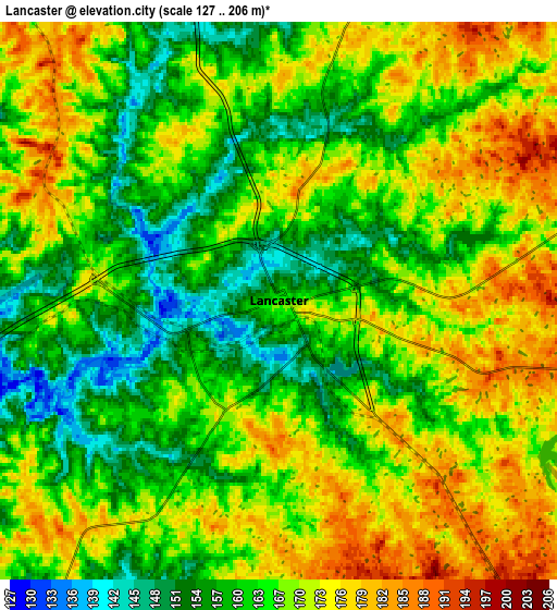
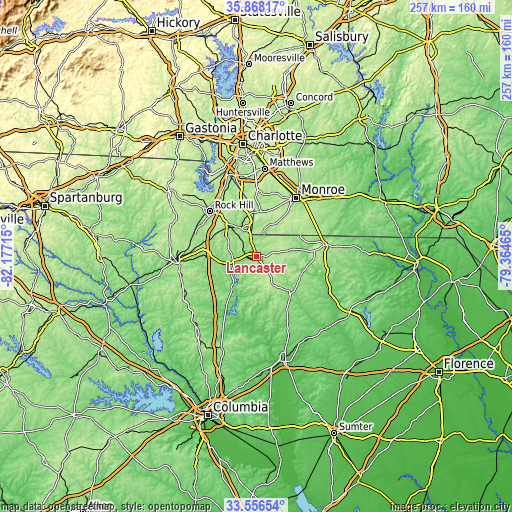
| \ | Map #1 | Map #2 | Topo.Map |
| Scale [m] | 128..189 m | 127..206 m | × |
| Scale [ft] | 420..620 ft | 417..676 ft | × |
| Average | 158.4 m = 520 ft | 166.3 m = 546 ft | × |
| Width | 8.03 km = 5 mi | 16.06 km = 10 mi | 257 km = 159.7 mi |
| Height | 8.03 km = 5 mi | 16.06 km = 10 mi | 257 km = 159.7 mi |
| ↑Max Latitude | 34.756543° | 34.792639° | 35.86817° |
| Latitude at center | 34.72043° | 34.72043° | 34.72043° |
| ↓Min Latitude | 34.684302° | 34.648158° | 33.55654° |
| ← Min Longitude | -80.814845° | -80.858791° | -82.17715° |
| Longitude center | -80.7709° | -80.7709° | -80.7709° |
| →Max Longitude | -80.726955° | -80.683009° | -79.36465° |
Nearby cities:
Cities around Lancaster sort by population:
• Rock Hill elevation 209 m
32.5 km,  314°
314°
• Waxhaw 203 m
22.8 km,  6°
6°
• Marvin 212 m
30.4 km,  352°
352°
• Lesslie 212 m
25.4 km,  318°
318°
• Mineral Springs 193 m
25.9 km,  21°
21°
• Elgin 183 m
7.1 km,  138°
138°
• Springdale 167 m
3.7 km,  201°
201°
• Kershaw 159 m
25.4 km, 137°
• Lancaster Mill 158 m
2.5 km,  240°
240°
• Great Falls 141 m
20.1 km,  216°
216°
• Irwin 152 m
5.6 km, 237°
• Catawba 170 m
19.5 km, 318°
Multilingual:
 En español:
Lancaster elevación 165 m.
 En France:
Lancaster élévation 165 m.
 Auf Deutsch:
Lancaster höhe über dem Meeresspiegel ist 165 m.

Sources and notes:
- [note 1] Map square and city borders are not equal. Map elevation data is calculated only from area inside that square.
- [src 1] Elevation data from geonames database provided with same terms of usage.
- [src 2] The elevation map of Lancaster is generated using elevation data from NASA's 3 arcsec (90m) resolution SRTM data.
- [src 3] Base (background) map © OpenStreetMap contributors tiles are generated by Geofabrik and OpenTopoMap.
Copyright & License:
This Lancaster Elevation Map is licensed under CC BY-SA. You may reuse any part from this page, if you give a proper credit by linking to this URL:
 More info on terms of use page.