Batesburg-Leesville elevation
Batesburg-Leesville (South Carolina, Lexington County), United States elevation is 198 meters and Batesburg-Leesville elevation in feet is 650 ft above sea level [src 1]. Batesburg-Leesville is a populated place (feature code) with elevation that is 81 meters (266 ft) smaller than average city elevation in United States.
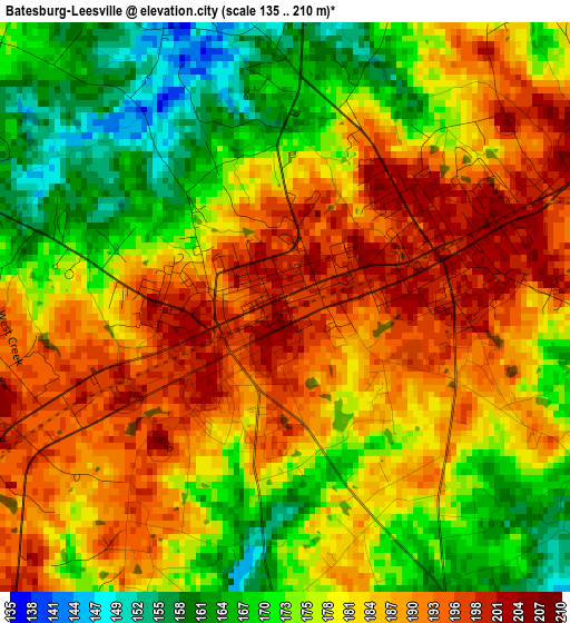
Below is the Elevation map of Batesburg-Leesville, which displays elevation range with different colors. Scale of the first map is from 135 to 210 m (443 to 689 ft) with average elevation of 180.8 meters (=593 ft) [note 1]
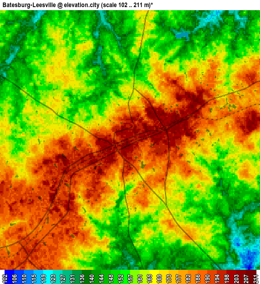
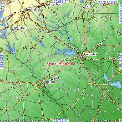
These maps also provides idea of topography and contour of this city, they are displayed at different zoom levels. More info about maps, scale and edge coordinates you can find below images.
| \ | Map #1 | Map #2 | Topo.Map |
| Scale [m] | 135..210 m | 102..211 m | × |
| Scale [ft] | 443..689 ft | 335..692 ft | × |
| Average | 180.8 m = 593 ft | 166.4 m = 546 ft | × |
| Width | 8.11 km = 5 mi | 16.22 km = 10.1 mi | 259.5 km = 161.2 mi |
| Height | 8.11 km = 5 mi | 16.22 km = 10.1 mi | 259.5 km = 161.2 mi |
| ↑Max Latitude | 33.946603° | 33.98305° | 35.06917° |
| Latitude at center | 33.91014° | 33.91014° | 33.91014° |
| ↓Min Latitude | 33.873661° | 33.837167° | 32.73513° |
| ← Min Longitude | -81.581275° | -81.625221° | -82.94358° |
| Longitude center | -81.53733° | -81.53733° | -81.53733° |
| →Max Longitude | -81.493385° | -81.449439° | -80.13108° |
Nearby cities:
Cities around Batesburg-Leesville sort by population:
• Lexington elevation 119 m
28.9 km,  74°
74°
• Irmo 107 m
38.1 km,  59°
59°
• Oak Grove 111 m
37.2 km,  77°
77°
• Red Bank 107 m
27.7 km, 84°
• Lake Murray of Richland 119 m
34.3 km,  47°
47°
• Batesburg 201 m
1 km,  255°
255°
• Saluda 147 m
23.9 km,  295°
295°
• South Congaree 60 m
37.1 km,  89°
89°
• Johnston 202 m
25.8 km,  250°
250°
• Leesville 199 m
2.3 km, 72°
• Chapin 139 m
33.3 km,  31°
31°
• Prosperity 166 m
33.3 km,  0°
0°
Multilingual:
 En español:
Batesburg-Leesville elevación 198 m.
 En France:
Batesburg-Leesville élévation 198 m.
 Auf Deutsch:
Batesburg-Leesville höhe über dem Meeresspiegel ist 198 m.
 На русском:
Batesburg-Leesville высота над уровнем моря 198 м
Sources and notes:
- [note 1] Map square and city borders are not equal. Map elevation data is calculated only from area inside that square.
- [src 1] Elevation data from geonames database provided with same terms of usage.
- [src 2] The elevation map of Batesburg-Leesville is generated using elevation data from NASA's 3 arcsec (90m) resolution SRTM data.
- [src 3] Base (background) map © OpenStreetMap contributors tiles are generated by Geofabrik and OpenTopoMap.
Copyright & License:
This Batesburg-Leesville Elevation Map is licensed under CC BY-SA. You may reuse any part from this page, if you give a proper credit by linking to this URL:
 More info on terms of use page.