Irmo elevation
Irmo (South Carolina, Lexington County), United States elevation is 107 meters and Irmo elevation in feet is 351 ft above sea level [src 1]. Irmo is a populated place (feature code) with elevation that is 172 meters (564 ft) smaller than average city elevation in United States.
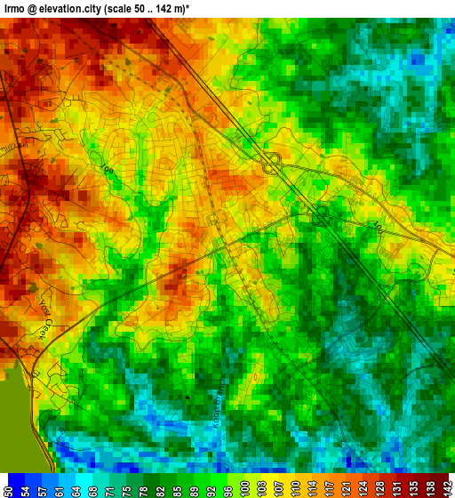
Below is the Elevation map of Irmo, which displays elevation range with different colors. Scale of the first map is from 50 to 142 m (164 to 466 ft) with average elevation of 96.2 meters (=316 ft) [note 1]
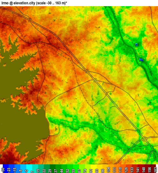
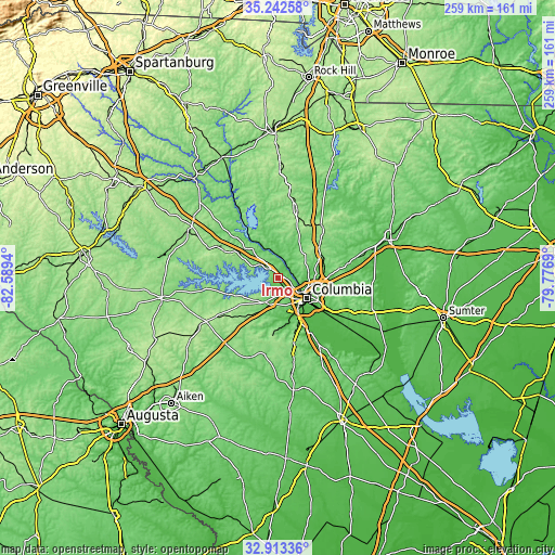
These maps also provides idea of topography and contour of this city, they are displayed at different zoom levels. More info about maps, scale and edge coordinates you can find below images.
| \ | Map #1 | Map #2 | Topo.Map |
| Scale [m] | 50..142 m | -30..163 m | × |
| Scale [ft] | 164..466 ft | -98..535 ft | × |
| Average | 96.2 m = 316 ft | 96 m = 315 ft | × |
| Width | 8.09 km = 5 mi | 16.19 km = 10.1 mi | 259 km = 160.9 mi |
| Height | 8.09 km = 5 mi | 16.19 km = 10.1 mi | 259 km = 160.9 mi |
| ↑Max Latitude | 34.122368° | 34.158739° | 35.24258° |
| Latitude at center | 34.08598° | 34.08598° | 34.08598° |
| ↓Min Latitude | 34.049577° | 34.013158° | 32.91336° |
| ← Min Longitude | -81.227095° | -81.271041° | -82.5894° |
| Longitude center | -81.18315° | -81.18315° | -81.18315° |
| →Max Longitude | -81.139205° | -81.095259° | -79.7769° |
Nearby cities:
Cities around Irmo sort by population:
• Columbia elevation 97 m
16.6 km,  124°
124°
• Saint Andrews 92 m
6.7 km,  132°
132°
• Lexington 119 m
12.6 km,  202°
202°
• West Columbia 87 m
14.4 km,  135°
135°
• Seven Oaks 73 m
5.3 km, 140°
• Cayce 78 m
16.7 km, 143°
• Forest Acres 76 m
19.3 km,  112°
112°
• Oak Grove 111 m
12.3 km,  162°
162°
• Red Bank 107 m
17.9 km, 196°
• Lake Murray of Richland 119 m
8.4 km,  297°
297°
• Springdale 74 m
15.7 km,  154°
154°
• Chapin 139 m
17.7 km, 300°
Multilingual:
 En español:
Irmo elevación 107 m.
 En France:
Irmo élévation 107 m.


Sources and notes:
- [note 1] Map square and city borders are not equal. Map elevation data is calculated only from area inside that square.
- [src 1] Elevation data from geonames database provided with same terms of usage.
- [src 2] The elevation map of Irmo is generated using elevation data from NASA's 3 arcsec (90m) resolution SRTM data.
- [src 3] Base (background) map © OpenStreetMap contributors tiles are generated by Geofabrik and OpenTopoMap.
Copyright & License:
This Irmo Elevation Map is licensed under CC BY-SA. You may reuse any part from this page, if you give a proper credit by linking to this URL:
 More info on terms of use page.